place

Thorpe, Surrey

Borough of RunnymedeEngvarB from July 2016Former civil parishes in SurreyPages with disabled graphsVillages in Surrey
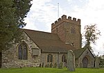
St Mary's Church, Thorpe geograph.org.uk 1165741

Thorpe is a village in northwest Surrey, England, around 20 miles (32 km) west of central London. It is in the Borough of Runnymede, between Egham, Virginia Water and Chertsey. It is adjacent to the M25, near the M3 — its ward covers 856 hectares (3.3 sq mi). Its traditional area with natural boundaries covers one square mile less. Thorpe is a former civil parish. Thorpe has been a manor since at least 1066 and has had a Christian place of worship since at least the 7th century. It has never had major industry and relies for much of its amenities on its two main adjoining towns. The River Bourne or Chertsey Bourne flows through its far south. In the south-east of the ward is Thorpe Park, one of England's largest amusement parks, alongside a separate watersports centre. Its second-tier local authority, Runnymede, is a largely suburban area.

Excerpt from the Wikipedia article Thorpe, Surrey (License: CC BY-SA 3.0, Authors, Images).

Thorpe, Surrey
The Gower, Borough of Runnymede

Geographical coordinates (GPS) Address Nearby Places
placeShow on map

Wikipedia: Thorpe, SurreyContinue reading on Wikipedia

Geographical coordinates (GPS)

Latitude Longitude
N 51.4069 ° E -0.5354 °
placeShow on map

Address

The Gower

The Gower
TW20 8UB Borough of Runnymede
England, United Kingdom
mapOpen on Google Maps

St Mary's Church, Thorpe geograph.org.uk 1165741
Share experience

Nearby Places

Borough of Runnymede

The Borough of Runnymede is a local government district with borough status in the English county of Surrey. It is a very prosperous part of the London commuter belt, with some of the most expensive housing in the United Kingdom outside central London, such as the Wentworth Estate. Runnymede is entirely unparished and is largely built-up. The borough's council is based in Addlestone; other settlements include Chertsey, Egham, Egham Hythe, Virginia Water, Englefield Green and Thorpe. At the 2011 Census, the population of the borough was 80,510. As of May 2023 it is in no overall control, with the Conservatives relying on the Ottershaw Independents to form an administration, with a supply and confidence deal.The borough was formed in 1974 under the Local Government Act 1972 by the merger of the Chertsey and Egham Urban Districts, both of which had been created in 1894. It is named after Runnymede, a water meadow on the banks of the River Thames, near Egham. Runnymede is connected with the sealing of Magna Carta by King John in 1215 and is the site of several significant monuments. Runnymede borders the boroughs of Spelthorne, Elmbridge, Woking and Surrey Heath, as well as the Royal Borough of Windsor and Maidenhead in Berkshire. The M25 motorway runs through Runnymede from south to north, with junctions at Chertsey and Egham, while train services in the borough are provided by South Western Railway on the Waterloo–Reading line and the Chertsey branch line.

Thorpe Hay Meadow
Thorpe Hay Meadow

Thorpe Hay Meadow is a 6.4-hectare (16-acre) biological Site of Special Scientific Interest west of Staines-upon-Thames in Surrey. It is owned and managed by the Surrey Wildlife Trust.Its habitat is (acid-alkali) neutral grassland and it contains Cynosurus cristatus - Centaurea nigra grassland as a notified feature. The site is thought to be the last remaining example of a Thames valley hay meadow in Surrey. It contains a range of lime-loving (calcicole) plants which are characteristic of this type of meadow. The grassland is dominated by rough-stalked meadow grass Poa trivialis, crested dog’s-tail grass Cynosurus cristatus, and lesser knapweed Centaurea nigra. Yellow rattle Rhinanthus minor, meadow-fescue grass Festuca pratensis, meadow barley Hordeum secalinum, smooth hawk’s-beard Crepis capillaris and common reed Phragmites australis are locally abundant, the last species being unusual in such dry situations. Other frequent species include meadow brome Bromus commutatus, a grass only recorded from one other Surrey location in recent years, meadow foxtail grass Alopecurus pratensis, Yorkshire-fog grass Holcus lanatus, pepper saxifrage Silaum silaus and meadow-sweet Filipendula ulmaria. Associated calcicole species include meadow cranesbill Geranium pratense, clustered bell-flower Campanula glomerata, cowslip Primula veris, hoary plantain Plantago media, salad burnet Sanguisorba minor and lady’s bedstraw Galium verum. The meadow is surrounded by old hedgerows with a variety of species such as ash Fraxinus excelsior, hawthorn Crataegus monogyna, field maple Acer campestre, spindle Euonymus europaeus, dogwood Cornus sanguinea, and buckthorn Rhamnus catharticus. A drainage ditch along two sides of the site supports five species of willow including purple willow Salix purpurea and almond willow Salix triandra. Common comfrey Symphytum officinale, ragged robin Lychnis flos-cuculi, cyperus sedge Carex pseudocyperus and the uncommon aquatic liverwort Riccia fluitans...along this ditch. A footpath from Staines passes through the site.