place

Point Roberts Light

Lighthouses in Washington (state)Transportation buildings and structures in Whatcom County, Washington

The Point Roberts Light is an aid to navigation located in Point Roberts, Whatcom County, Washington State, United States. The skeletal structure overlooks the Strait of Georgia from the end of a peninsula extending southward from Delta, British Columbia, Canada, across the 49th parallel into the U.S. It is part of Lighthouse Marine Park, a 21-acre (8.5 ha) recreational area operated by Whatcom County Parks and Recreation.In 1908, the federal government bought 21 acres (8.5 ha) at the end of the peninsula for a light station. A true lighthouse was never built and the land was transferred to Whatcom County for use as a county park. In 2000, the Point Roberts Lighthouse Society was formed with the purpose of building a proper lighthouse on the point. According to a 2014 presentation to the Whatcom County Parks and Recreation Committee, the society has completed architectural designs and has funding in place with the goal of seeing the project, which would include a U.S. Coast Guard-approved navigational light, through to completion in 2015.

Excerpt from the Wikipedia article Point Roberts Light (License: CC BY-SA 3.0, Authors).

Point Roberts Light
Marine Drive,

Geographical coordinates (GPS) Address Nearby Places
placeShow on map

Wikipedia: Point Roberts LightContinue reading on Wikipedia

Geographical coordinates (GPS)

Latitude Longitude
N 48.9715 ° E -123.0827 °
placeShow on map

Address

Group Camp E

Marine Drive
98281
Washington, United States
mapOpen on Google Maps

Share experience

Nearby Places

Tsawwassen
Tsawwassen

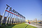
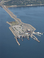
Tsawwassen (English: tə-WAH-sən) is a suburban, mostly residential community on a peninsula in the southwestern corner of the City of Delta in British Columbia, Canada. It provides the only road access to the American territory on the southern tip of the peninsula, the community of Point Roberts, Washington, via 56th Street. It is also the location of Tsawwassen Ferry Terminal, part of the BC Ferries, built in 1959 to provide foot-passenger and motor vehicle access from the Lower Mainland to the southern part of Vancouver Island and the southern Gulf Islands. Because Tsawwassen touches a shallow bank (Roberts Bank), the ferry terminal is built at the southwestern end of a 3 km (1.9 mi) causeway (part of Highway 17) that juts into the Strait of Georgia. Boundary Bay Airport, a major training hub for local and international pilots which also provides local airplane and helicopter service, is ten minutes away. The Roberts Bank Superport is also nearby. To the northwest of the community are the lands of Tsawwassen First Nation ("TFN"), a people of Coast Salish ancestry who have used this land since at least 200 B.C. Having been "stripped of their lands, rights and resources" by European colonizers throughout the 19th century, and in accordance with a 2009 treaty with British Columbia, their territory now consists of approximately 724 ha (1,790 acres) of treaty settlement land, bounded by the Strait of Georgia on the west, the 2600 block to the north, the 4800 block to the east, and the 1200 block to the south. While also part of TFN lands, the 92-lot residential subdivision of Stahaken was leased for use by the (then) Tsawwassen Indian Reserve to Staheken Developments Ltd. in 1989 for a 99-year term. It was then developed in a partnership between Stahaken Development Ltd. and the Municipality of Delta. As such it is commonly thought of and serviced in the same manner as other subdivisions in the community of Tsawwassen. Stahaken residents are represented by the Stahaken Homeowners Association.

Roberts Bank Superport

Roberts Bank is home to a twin-terminal port facility located on the mainland coastline of the Strait of Georgia in Delta, British Columbia, Canada. Opened in 1970 with Westshore Terminals as its only tenant, Roberts Bank was expanded in 1983–84, and in June 1997 opened a second terminal, the GCT Deltaport container facility. Part of Port of Vancouver, Roberts Bank is also known as the Outer Harbour of Canada's busiest port. Westshore is the busiest single coal export terminal in North America and is operated by the Westar Group on a long-term contract. It typically ships over 20 million tonnes of export coal a year and early in 2010 completed a $49-million equipment upgrade, bringing its capacity from 24 million to 29 million tonnes per year. Some of this coal is metallurgical coal from mines in the interior of British Columbia, some of which are operated by Teck Resources. This coal mined within British Columbia pays a provincial carbon tax on its embodied emissions. However, some of the coal exported through the Roberts Bank is mined within the United States, and is exported through Canada to China. Communities along the West Coast of the United States have rejected proposals for coal export terminals for environmental reasons, and so the Roberts Bank Superport is the only way for coal producers in the Powder River Basin to export coal to Asia. The American coal exported through Roberts Bank does not pay a provincial carbon tax. This practice has been criticized by environmentalists in British Columbia.Like the Tsawwassen Ferry Terminal to the southeast, Roberts Bank was built at the end of a long causeway over a shallow bank. Originally created as a 20-hectare (49-acre) pod of reclaimed land for a major coal port, it is now four times that size. In January 2010, Deltaport added a third berth and doubled its capacity. It is now one of the busiest import/export ports in North America and a major hub for container trucking companies. Roberts Bank is serviced by the Robert's Bank Rail Corridor, which serves CN Rail, CP Rail, and BNSF Railway trains. It opened on April 16 1970 under the B.C. Harbours Board. Additionally, Seaspan International provides tugboat services to both terminals at peninsula.