place

Kelling

Civil parishes in NorfolkNorth NorfolkVillages in Norfolk
Stmaryskelling
Stmaryskelling

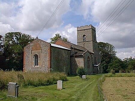
Kelling (also known as Low Kelling and as Lower Kelling) is a village and a civil parish in the English county of Norfolk. The village is 10.1 miles (16.3 km) west of Cromer, 26 miles (42 km) north of Norwich, and 130 miles (210 km) northeast of London. The village straddles the A149 Coast road between Kings Lynn and Great Yarmouth. The villages name means 'Cylla's/Ceolla's people'.The nearest railway station is at Sheringham for the Bittern Line which runs between Sheringham, Cromer, and Norwich. The nearest airport is Norwich International Airport. The village lies within the Norfolk Coast AONB (Area of Outstanding Natural Beauty) and the North Norfolk Heritage Coast. Changes in government policy have discontinued management of coastal erosion in North Norfolk.

Excerpt from the Wikipedia article Kelling (License: CC BY-SA 3.0, Authors, Images).

Kelling
The Street, North Norfolk

Geographical coordinates (GPS) Address Nearby Places
placeShow on map

Wikipedia: KellingContinue reading on Wikipedia

Geographical coordinates (GPS)

Latitude Longitude
N 52.94 ° E 1.11 °
placeShow on map

Address

The Street

The Street
NR25 7EL North Norfolk
England, United Kingdom
mapOpen on Google Maps

Stmaryskelling
Stmaryskelling
Share experience

Nearby Places

Randall's Folly
Randall's Folly

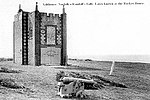
Randall's Folly was a building on the coast at Salthouse, Norfolk, England. No trace of it remains, largely because of coastal erosion.Although called a folly, the building was habitable. It was built some time around 1860 by Onesiphorus Randall (1798–1873) – a locally born man who had made his fortune as a London property speculator – and sat on a mound of land called the "Great Eye" (shown on later maps as "Lodge Hill"). The ground floor comprised a pair of arches, each with a pair of large wooden doors, allowing Randall to drive his horse carriage in at one side and, after a stay, out from the other. Pictures show the building to be two-storey, with crenellated decoration.After Randall's death, the building was purchased by the Board of Trade for use as a coastguard station, equipped with a rocket cart and an adjacent cannon, for the deployment of a breeches buoy. This led to the building being known as Rocket House.From the 1920s, it was in use as a holiday home, known as Rocket Brigade House.In 1937 it was purchased privately and again renamed, this time as Great Eye Folly. It was rented by the writer Sylvia Townsend Warner and her partner Valentine Ackland from 1950 to 1951, during which time Warner wrote her final novel The Flint Anchor (published 1954) there. She described the house in a 1950 letter to Alyse Gregory: ...I think Valentine will have told you about the Great Eye Folly. I have the oddest impressions of it, since we were only there for about fifteen minutes, and conversing all the time with its owners. But the first five of those minutes were enough to enchant me. It is the sort of house one tells oneself to sleep with, and sometimes I almost suppose that it is really one of my dream-houses, and no such solid little assertion of the rectangle breaks the long sky-line of salt-marsh and sea. The building was badly damaged by the North Sea flood of 1953 and was demolished in June 1956.A painting of the folly by John Arnesby Brown, titled The Watch Tower, was exhibited at the Royal Academy in 1923; the work is now in the Laing Art Gallery, who also hold a letter from Brown, describing the work's setting.

Salthouse
Salthouse

Salthouse is a village and a civil parish in the English county of Norfolk. It is situated on the salt marshes of North Norfolk. It is 3.8 miles (6.1 km) north of Holt, 5.4 miles (8.7 km) west of Sheringham and 26.3 miles (42.3 km) north of Norwich. The village is on the A149 coast road between King's Lynn and Great Yarmouth. The nearest railway station is at Sheringham for the Bittern Line which runs between Sheringham, Cromer and Norwich. The nearest airport is Norwich International Airport. The landscape around Salthouse lies within the Norfolk Coast AONB (Area of Outstanding Natural Beauty) and the North Norfolk Heritage Coast. The civil parish has an area of 6.22 km2 (2.40 sq mi) and in 2001 had a population of 196 in 88 households, the population increasing to 201 at the 2011 Census. For the purposes of local government, the parish falls within the district of North Norfolk. Changes in governmental policy have discontinued management of coastal erosion in North Norfolk.The Parish Church of St Nicholas is a Grade I listed building; it was rebuilt by Sir Henry Heydon (died 1504). From 2001 to 2011 the church in Salthouse was the setting for an annual month-long contemporary art exhibition by artists with a Norfolk connection. The exhibition was organised by the North Norfolk Exhibition Project (NNEP). The curator of Salthouse 09 was Simon Martin from Pallant House Gallery in Chichester, on a theme of 'Salt of the Earth.' The exhibition ran from 2 July to 2 August 2009 and included ceramics, film, installation, painting, printmaking and sculpture. The 50 artists in the exhibition included Maggi Hambling, Gary Breeze, Kabir Hussain, Colin Self, Margaret Mellis and Ana Maria Pacheco and the potters Ruthanne Tudball and Stephen Parry. The Salthouse Sculpture Trail features a number of local artist's sculptures over approximately ten miles, linking Salthouse Church and Heath, Holt town, Holt Country Park, Kelling Heath Holiday Park and Kelling Heath.