Smith Hill, Providence, Rhode Island
Historic districts on the National Register of Historic Places in Rhode IslandNRHP infobox with nocatNeighborhoods in Providence, Rhode IslandProvidence, Rhode Island Registered Historic Place stubsRhode Island geography stubs

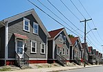
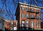
Smith Hill is a neighborhood in Providence, Rhode Island. Its traditional bounds are the Woonasquatucket River, the Chad Brown public housing complex, Interstate 95 and West River. The Roger Williams Medical Center (RWMC) is located in the Smith Hill neighborhood and is adjacent to the VA hospital. The Rhode Island State House is also located on the border with Downtown. The name 'Smith Hill' is therefore used as a metonym for the Rhode Island state government and the Rhode Island General Assembly.
Excerpt from the Wikipedia article Smith Hill, Providence, Rhode Island (License: CC BY-SA 3.0, Authors, Images).Smith Hill, Providence, Rhode Island
Smith Street, Providence
Geographical coordinates (GPS) Address Nearby Places Show on map
Geographical coordinates (GPS)
| Latitude | Longitude |
|---|---|
| N 41.8339 ° | E -71.4223 ° |
Address
Smith Street 309
02908 Providence
Rhode Island, United States
Open on Google Maps


