place

St. Onuphrius Monastery

Eastern Orthodox monasteries in IsraelGreek Orthodox monasteriesGreek Orthodoxy in the Middle East
Chakel dama
Chakel dama

The St. Onuphrius Monastery (Greek: Ιερά Μονή του Οσίου Ονουφρίου) is an Orthodox monastery for women located in the potter's field (Akeldama in Aramean) that the Jewish elders purchased with the thirty pieces of silver returned by Judas Iscariot that had been given for betraying Jesus. The location is south of East Jerusalem and on the southern slope of the Gehenna valley, close to the Kidron Valley. Subject to the Greek Orthodox Church of Jerusalem, it is named after the fourth-century anchorite monk Saint Onuphrius.

Excerpt from the Wikipedia article St. Onuphrius Monastery (License: CC BY-SA 3.0, Authors, Images).

St. Onuphrius Monastery
The American Road, Jerusalem Abu Tor

Geographical coordinates (GPS) Address External links Nearby Places
placeShow on map

Wikipedia: St. Onuphrius MonasteryContinue reading on Wikipedia

Geographical coordinates (GPS)

Latitude Longitude
N 31.768055555556 ° E 35.233333333333 °
placeShow on map

Address

חקל דמא

The American Road
9355223 Jerusalem, Abu Tor
Jerusalem District, Israel
mapOpen on Google Maps

linkWikiData (Q3320224)
linkOpenStreetMap (376134177)

Chakel dama
Chakel dama
Share experience

Nearby Places

Valley of Hinnom (Gehenna)

The Valley of Hinnom (Hebrew: גֵּיא בֶן־הִנֹּם‎, romanized: Gēʾ ḇen-Hīnnōm, lit. 'Valley of Hinnom’s son') is a historic valley surrounding Ancient Jerusalem from the west and southwest. The valley is also known by the name Gehinnom (גֵיא־הִנֹּם‎ Gēʾ-Hīnnōm, lit. 'Valley of Hinnom'), an alternative Biblical Hebrew form which survived into Aramaic and has received various fundamental theological connotations, and by the Greek and Syriac transliteration Gehenna (Γέεννα Géenna/ܓܼܼܗܲܢܵܐ Gihanna).The Valley of Hinnom is first mentioned in the Hebrew Bible as part of the border between the tribes of Judah and Benjamin (Joshua 15:8). During the late First Temple period, it was the site of the Tophet, where some of the kings of Judah had sacrificed their children by fire (Jeremiah 7:31). Thereafter, it was cursed by the biblical prophet Jeremiah (Jeremiah 19:2–6). In later Jewish rabbinic literature, Gehinnom became associated with divine punishment in Jewish Apocalypticism as the destination of the wicked. It is different from the more neutral term Sheol, the abode of the dead. The King James Version of the Bible translates both with the Anglo-Saxon word hell. The Valley of Hinnom is the Modern Hebrew name for the valley surrounding the Old City of Jerusalem and the adjacent Mount Zion from the west and south. It meets and merges with the Kidron Valley, the other principal valley around the Old City, near the Pool of Siloam which lie to the southeastern corner of Ancient Jerusalem. It is also known as Wadi er-Rababi (Arabic: وادي الربابة "valley of the Rebab"). The northwestern part of the valley is now an urban park. In Judaism, the term Gehinnom is used for the realm in which the wicked expiate their sins.

Silwan
Silwan

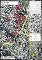
Silwan or Siloam (Arabic: سلوان, romanized: Silwan; Greek: Σιλωὰμ, romanized: Siloam; Hebrew: כְּפַר הַשִּׁילוֹחַ, romanized: Kfar ha-Shiloaḥ) is a predominantly Palestinian neighborhood in East Jerusalem, on the southeastern outskirts of the current Old City of Jerusalem.It is mentioned in the Hebrew Bible and the New Testament; in the latter it is the location of Jesus' healing the man blind from birth. Medieval Silwan began as a farming village, dating back to the 7th century according to local traditions, while the earliest mention of the village is from the year 985. From the 19th century onwards, the village was slowly being incorporated into Jerusalem until it became an urban neighborhood. After the 1948 war, the village came under Jordanian rule. Jordanian rule lasted until the 1967 Six-Day War, since which it has been occupied by Israel. Silwan is administered as part of the Jerusalem Municipality. In 1980, Israel incorporated East Jerusalem (of which Silwan is a part) into its claimed capital city Jerusalem through the Jerusalem Law, a basic law in Israel. The move is considered by the international community as illegal under international law, but the Israeli government disputes this. According to Haaretz, the Israeli government has worked closely with the right-wing settler organization Ateret Cohanim to evict Palestinians living on property whether classified formerly as heqdesh (property pledged to a temple) or not, especially in the Batan el-Hawa area of Silwan.Depending on how the neighborhood is defined, the Palestinian residents in Silwan number 20,000 to 50,000 while there are about 500 to 2,800 Jews.

Siloam tunnel
Siloam tunnel

The newer Siloam Tunnel (Hebrew: נִקְבַּת הַשִּׁלֹחַ, Nikbat HaShiloaḥ), also known as Hezekiah's Tunnel (Hebrew: תעלת חזקיהו, Te'alát Ḥizkiyáhu), is a water tunnel that was carved within the City of David in ancient times, now located in the Arab neighborhood of Silwan in eastern Jerusalem. Its popular name is due to the most common hypothesis that it dates from the reign of Hezekiah of Judah (late 8th and early 7th century BC) and corresponds to the "conduit" mentioned in 2 Kings 20:20 in the Hebrew Bible. According to the Bible, King Hezekiah prepared Jerusalem for an impending siege by the Assyrians, by "blocking the source of the waters of the upper Gihon, and leading them straight down on the west to the City of David" (2 Chronicles 32:30). By diverting the waters of the Gihon, he prevented the enemy forces under Sennacherib from having access to water. Support for the dating to Hezekiah's period is derived from the Biblical text that describes construction of a tunnel and to radiocarbon dates of organic matter contained in the original plastering. However, the dates were challenged in 2011 by new excavations that suggested an earlier origin in the late 9th or early 8th century BC.The tunnel leads from the Gihon Spring to the Pool of Siloam. If indeed built under Hezekiah, it dates to a time when Jerusalem was preparing for an impending siege by the Assyrians, led by Sennacherib. Since the Gihon Spring was already protected by a massive tower and was included in the city's defensive wall system, Jerusalem seems to have been supplied with enough water in case of siege even without this tunnel. According to Aharon Horovitz, director of the Megalim Institute, the tunnel can be interpreted as an additional aqueduct designed for keeping the entire outflow of the spring inside the walled area, which included the downstream Pool of Siloam, with the specific purpose of withholding water from any besieging forces. Both the spring itself, and the pool at the end of the tunnel, would have been used by the inhabitants as water sources. Troops positioned outside the walls wouldn't have reached any of it, because even the overflow water released from the Pool of Siloam would have fully disappeared into a karstic system located right outside the southern tip of the city walls. In contrast to that, the previous water system did release all the water not used by the city population into the Kidron Valley to the east, where besieging troops could have taken advantage of it. The curving tunnel is 583 yards (533 m; about 1⁄3 mile) long and by using the 12 inch (30 cm) altitude difference between its two ends, which corresponds to a 0.06 percent gradient, the engineers managed to convey the water from the spring to the pool. According to the Siloam inscription, the tunnel was excavated by two teams, one starting at each end of the tunnel and then meeting in the middle. The inscription is partly unreadable at present, and may originally have conveyed more information than this. It is clear from the tunnel itself that several directional errors were made during its construction. Recent scholarship has discredited the idea that the tunnel may have been formed by substantially widening a pre-existing natural karst. How the Israelite engineers dealt with the difficult feat of making two teams digging from opposite ends meet far underground is still not fully understood, but some suggest that the two teams were directed from above by sound signals generated by hammering on the solid rock through which the tunnelers were digging.

Zion
Zion

Zion (Hebrew: צִיּוֹן Ṣīyyōn, LXX Σιών, also variously transliterated Sion, Tzion, Tsion, Tsiyyon) is a placename in the Hebrew Bible used as a synonym for Jerusalem as well as for the Land of Israel as a whole. The name is found in 2 Samuel (5:7), one of the books of the Hebrew Bible dated to before or close to the mid-6th century BCE. It originally referred to a specific hill in Jerusalem (Mount Zion), located to the south of Mount Moriah (the Temple Mount). According to the narrative of 2 Samuel 5, Mount Zion held the Jebusite fortress of the same name that was conquered by David and was renamed the City of David. That specific hill ("mount") is one of the many squat hills that form Jerusalem, which also includes Mount Moriah (the Temple Mount), the Mount of Olives, etc. Over many centuries, until as recently as the Ottoman era, the city walls of Jerusalem were rebuilt many times in new locations, so that the particular hill known as Mount Zion is no longer inside the city wall, but its location is now just outside the portion of the Old City wall forming the southern boundary of the Jewish Quarter of the current Old City. Most of the original City of David itself is thus also outside the current city wall. The term Tzion came to designate the area of Davidic Jerusalem where the fortress stood, and was used as well as synecdoche for the entire city of Jerusalem; and later, when Solomon's Temple was built on the adjacent Mount Moriah (which, as a result, came to be known as the Temple Mount) the meanings of the term Tzion were further extended by synecdoche to the additional meanings of the Temple itself, the hill upon which the Temple stood, the entire city of Jerusalem, the entire biblical Land of Israel, and "the World to Come", the Jewish understanding of the afterlife.