place

Lehigh River

Delaware ValleyHistory of Allentown, PennsylvaniaLehigh RiverPocono MountainsRivers of Carbon County, Pennsylvania
Rivers of Lackawanna County, PennsylvaniaRivers of Lehigh County, PennsylvaniaRivers of Luzerne County, PennsylvaniaRivers of Monroe County, PennsylvaniaRivers of Northampton County, PennsylvaniaRivers of Wayne County, PennsylvaniaScenic Rivers of PennsylvaniaTributaries of the Delaware RiverUse American English from July 2022
Lehigh River
Lehigh River

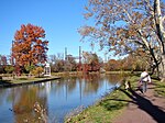
The Lehigh River is a 109-mile-long (175 km) tributary of the Delaware River in eastern Pennsylvania. The river flows in a generally southward pattern from the Pocono Mountains in Northeastern Pennsylvania through Allentown and much of the Lehigh Valley before joining the Delaware River in Easton. Part of the Lehigh River and a number of its tributaries are designated Pennsylvania Scenic Rivers by the state's Department of Conservation and Natural Resources. The river's name is an anglicisation of the Lenape name for the river, Lechewuekink, which means "where there are forks". Both Lehigh County and Lehigh Valley are named for the river. Between 1821 and 1966, the Lehigh River was owned by the Lehigh Coal and Navigation Company, making it the only privately owned river in the United States. This private ownership continued until a local representative, Samuel Frank, promoted a bill to return control of the river to the state in 1967. According to an environmental report from a Pennsylvania nonprofit research center, the Lehigh River watershed is ranked second nationally in the volume of toxic substances released into it in 2020. The study mirrored a previous report by the state's Department of Environmental Protection that found most of the county's waterways unsafe for swimming or aquatic life.

Excerpt from the Wikipedia article Lehigh River (License: CC BY-SA 3.0, Authors, Images).

Lehigh River
D&L Trail, Easton

Geographical coordinates (GPS) Address Nearby Places
placeShow on map

Wikipedia: Lehigh RiverContinue reading on Wikipedia

Geographical coordinates (GPS)

Latitude Longitude
N 40.688888888889 ° E -75.204722222222 °
placeShow on map

Address

D&L Trail

D&L Trail
18042 Easton
Pennsylvania, United States
mapOpen on Google Maps

Lehigh River
Lehigh River
Share experience

Nearby Places

Pennsylvania Canal (Delaware Division)

The Delaware Division of the Pennsylvania Canal, more commonly called the Delaware Canal, runs for 60 miles (97 km) parallel to the right bank of the Delaware River from the entry locks near the mouth of the Lehigh River and terminal end of the Lehigh Canal at Easton south to Bristol. At Easton, which today is the home of The National Canal Museum, the Delaware Canal also connected with the Morris Canal built to carry anthracite coal to energy-starved New Jersey industries. Later, with a crossing-lock constructed at New Hope, the New Hope 'outlet lock' (1847) connected by Cable Ferry to enter at Lambertville, NJ; where it connected to a feeder navigation/canal that began at Bull's Island opposite Lumberville; which then ran over 22 miles (35 km) south along the New Jersey bank of the Delaware River through Trenton to Bordentown, the west end of the Delaware and Raritan Canal (1834) to New York City via New Brunswick. The Commonwealth of Pennsylvania built the Delaware canal to feed anthracite stone coal to energy-hungry Philadelphia as part of its transportation infrastructure building plan known as the Main Line of Public Works—a legislative initiative creating a collection of self-reinforcing internal improvements to commercial transportation capabilities. The Delaware Canal, like the Lehigh Canal, was primarily meant to carry anthracite coal and other bulk goods such as gravel and limestone, cement, and lumber—from northeastern Pennsylvania to Philadelphia. In reverse flow, the two canals carried manufactured goods, iron products and (a few decades later) steel products to the northeastern cities. The Delaware and Lehigh Canals also connected from Easton by ferry services across the Delaware River to New Jersey and the Delaware and Raritan Canal, connecting industrial loads to New York City. First opened in 1832, the Delaware Canal still has most of its original locks, aqueducts, and overflows. Although the two canals reached their peak shipping in 1855, after which coal transport down the Lehigh corridor was taken up increasingly by railroads, the canals stayed in operation until the Great Depression in the early 1930s. According to the National Park Service, it was the "longest-lived canal in the country".

Peace Candle
Peace Candle

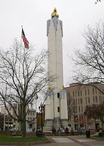
The Peace Candle is a tower-like structure erected every Christmas season in Easton, Pennsylvania. The approximately 106-foot (32 m) tall structure, which resembles a giant candle, is assembled each year over the Soldiers' & Sailors' Monument, a Civil War memorial located in the city's Centre Square. It is typically assembled in mid November and lighted over Thanksgiving weekend and disassembled in early February each year.The Peace Candle was first erected in 1951, and has been put up every year (except two) since then. Due to damage or disrepair, the Peace Candle has been replaced with new candle structures twice since the original construction. The first candle lasted until 1968, the second candle from 1969 to 1989, and the current candle was built in 1990.The structure is dedicated to the Easton area men and women who have served or are serving in the United States armed forces.It has been said to be the largest non-wax Christmas candle in the country. Although conceived with the hopes of restoring Easton's pre-20th century reputation for elaborate Christmas decorations, city officials also believed a candle would serve as a symbol of peace for all religions and denominations. Due to its symbolism for peace and its placement over a Civil War monument, the candle has been the site of several anti-war protests over the decades. Some have criticized the Peace Candle, calling it a symbol of the over-commercialization of Christmas, and condemning the fact that it covers a war monument.