Ixtapaluca
IxtapalucaPopulated places in the State of Mexico

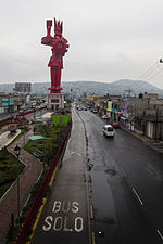
Ixtapaluca is a city and a municipality in the eastern part of the State of Mexico in Mexico. It lies between the Federal District and the western border of the state of Puebla. The name Ixtapaluca means "Where the salt gets wet".As of 2006, Ixta included part of the world's largest mega-slum, along with Chalco and Neza.
Excerpt from the Wikipedia article Ixtapaluca (License: CC BY-SA 3.0, Authors, Images).Ixtapaluca
Calle Francisco Javier Mina, Ixtapaluca
Geographical coordinates (GPS) Address Nearby Places Show on map
 Continue reading on Wikipedia
 Geographical coordinates (GPS)
| Latitude | Longitude |
|---|---|
| N 19.318611111111 ° | E -98.882222222222 ° |
Address
Calle Francisco Javier Mina
Calle Francisco Javier Mina
56530 Ixtapaluca
Mexico
Open on Google Maps