Rivière de la Somme
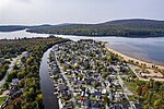
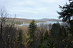
The Rivière de la Somme is a watercourse flowing in the municipalities of Saint-Gabriel-de-Valcartier and Shannon, in the La Jacques-Cartier Regional County Municipality, in the administrative region of Capitale-Nationale, in Quebec, in Canada. Located in a forest environment, this river is part of the territory of the Duchesnay tourist resort. Forestry has been the dominant economic activity in this sector since XVIIIth. In XIXth the recreational-tourist activities were highlighted. The river is generally frozen from November to April; however, the period of safe circulation on the ice is usually from mid-December to the end of March. The water level of the river varies with the seasons and the precipitation.
Excerpt from the Wikipedia article Rivière de la Somme (License: CC BY-SA 3.0, Authors).Rivière de la Somme
Route Cadieux,
Geographical coordinates (GPS) Address Nearby Places Show on map
 Continue reading on Wikipedia
 Geographical coordinates (GPS)
| Latitude | Longitude |
|---|---|
| N 46.95028 ° | E -71.59528 ° |
Address
Route Cadieux
Route Cadieux
Quebec, Canada
Open on Google Maps