Rivière aux Pins (Saint-Joseph Lake)
.jpg)
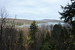
The Rivière aux Pins is a watercourse flowing in several municipalities of La Jacques-Cartier Regional County Municipality, in the administrative region of Capitale-Nationale, in Quebec, in Canada. The municipalities crossed by this 32.7 kilometres (20.3 mi) river (measured by the current), are Saint-Gabriel-de-Valcartier (18.9 km), Shannon (11,0 km) and Fossambault-sur-le-Lac (2.8 km). The lower part of the Pins river valley is mainly served by the Duchesnay road and the Kilkenny street (west bank). The rest of this river is served by various secondary forest roads.Forestry is the main economic activity in the sector; recreational tourism, second. Located to the northwest of the city of Quebec, Saint-Joseph Lake is a very popular site for recreational tourism activities including the resort. The surface of the Rivière aux Pins (except the rapids areas) is generally frozen from the beginning of December to the end of March; safe circulation on the ice is generally done from the end of December to the beginning of March. The water level of the river varies with the seasons and the precipitation.
Excerpt from the Wikipedia article Rivière aux Pins (Saint-Joseph Lake) (License: CC BY-SA 3.0, Authors, Images).Rivière aux Pins (Saint-Joseph Lake)
6e Rue,
Geographical coordinates (GPS) Address Nearby Places Show on map
 Continue reading on Wikipedia
 Geographical coordinates (GPS)
| Latitude | Longitude |
|---|---|
| N 46.90111 ° | E -71.62611 ° |
Address
Domaine de la Rivière aux Pins
6e Rue
G3N 1X7
Quebec, Canada
Open on Google Maps