place

City Adult Learning Centre

1963 establishments in OntarioAdult educationAlternative educationEducational institutions established in 1963High schools in Toronto
Schools in the TDSB
City Adult Learning Centre

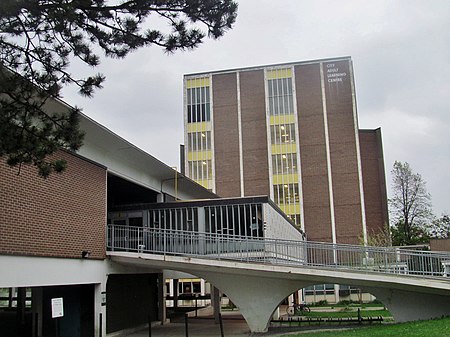
City Adult Learning Centre (CALC), formerly known as Parkway Vocational School and Parkview Secondary School is an adult high school serving the Riverdale community in Toronto, Ontario, Canada, overseen by the Toronto District School Board. Prior to 1998, it was part of the Toronto Board of Education. From the beginning, the school offered vocational and technical courses. It has since evolved into a conventional adult high school offering EdVance (18–20) and adult (21 and over) classes.

Excerpt from the Wikipedia article City Adult Learning Centre (License: CC BY-SA 3.0, Authors, Images).

City Adult Learning Centre
Danforth Avenue, Toronto

Geographical coordinates (GPS) Address Nearby Places
placeShow on map

Wikipedia: City Adult Learning CentreContinue reading on Wikipedia

Geographical coordinates (GPS)

Latitude Longitude
N 43.674972 ° E -79.360174 °
placeShow on map

Address

Danforth Avenue 1
M4K 1M8 Toronto
Ontario, Canada
mapOpen on Google Maps

City Adult Learning Centre
Share experience

Nearby Places

Castle Frank Brook
Castle Frank Brook

Castle Frank Brook is a buried creek and south-west flowing tributary of the Don River in central and north-western Toronto, Ontario, originating near the intersection of Lawrence Avenue and Dufferin Street. Residential and industrial development in the former suburban cities of York and North York have obliterated nearly all traces of its original course and topography in the uppermost reaches, but the original stream valley is evident in several older districts bordering the lower reaches. Sections of the lower valley include Cedarvale Park ravine, the Nordheimer Ravine near the intersection of St. Clair Avenue and Spadina Road, and the Rosedale Ravine just above the brook's confluence with the Don. Water still runs in short segments in Cedarvale Park and the Nordheimer Ravine but this is only a collection of surface runoff and ravine slope seepage. The channels are all artificially created and run into a storm sewer that carries the remnants of the brook. The southern section of Vaughan Road roughly parallels the brook's course, bypassing the steep slopes of the Cedarvale ravine. The brook's topographic influence is still evident at Ramsden Park, to the north of the intersection of Avenue Road and Davenport Road, representing the boundary of the densely developed Yorkville district. The Toronto Transit Commission's Spadina subway line follows the path of the creek from Eglinton West station to St. Clair West station, finally deviating southward at Spadina Road. The brook is named for the summer residence of Ontario's first colonial governor, John Graves Simcoe, which in turn was named for Simcoe's son, Francis Gwillim. It was built either on the west side of the Don River near the modern Prince Edward (Bloor) Viaduct, or on the east side of Cabbagetown near the river. The home featured a façade in the Georgian architectural style. It was abandoned when Simcoe returned to England in 1794, and burned down in 1829. Castle Frank subway station takes its name from the former residence. A second home of the same name was built north of this site by Sir Edward Kemp. It was demolished in 1962 for the current Rosedale Heights School of the Arts. The site of the original summer home can be seen from aerial photos as a partially cleared area with a ring-like shape.

Necropolis Chapel
Necropolis Chapel

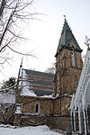
The Necropolis Chapel was built by the architect Henry Langley in 1872 in the Gothic Revival style. It is located at 200 Winchester Street, Toronto, in the Cabbagetown neighbourhood at the edge of the Don Valley. Its entrance is marked by masonry signage Toronto Crermatorium Chapel and massing of a pointed barrel vault that leads to the central part of the chapel. The latter has a simple gable roof, whose steep, pitched gables raise high to a sharp ridge. The square tower is placed on the east side of the plan, giving the edifice a picturesque, asymmetrical appearance that is tightly linked to the Gothic. This particularity shifts the center of gravity of the building, giving it an ascending diagonal axis. The steep slope of the roof along with the placement and configuration of the tower give the building a jagged, pointed contour. The dominant material used is yellow brick, with a stone entrance vault. The roof is covered with two different patterns of slates and is unique for its multicolored appearance. There are a number of High Gothic Revival style elements, which include rich wrought iron on fences, detailed trefoils carved on the stone facade, ridge cresting on the tower roof and finials. White sawn wood ornament decorates the eaves of the porch and the barge-boards of the steep gables of the lych-gate and the caretaker’s house (living room, dining room, kitchen, front and back staircases and upper bedrooms). The basement crematorium has been decommissioned. Kept almost intact over time, the Necropolis Chapel, lych-gate, and caretaker's cottage fit perfectly into their surrounding context, which is the heritage conservation district Cabbagetown.