place

St Helen's Church, Santon

Former churches in Norfolk

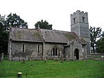
St Helen's Church was a church located near Santon, Norfolk, England. Its site is a scheduled monument. It was no longer in existence by 1368.The church is noted in the Domesday Book: "Among the lands of Stigand the archbishop which William de Noiers keeps for the use of the king, in Thetford ... one church of St. Helen, with one ploughland ..."

Excerpt from the Wikipedia article St Helen's Church, Santon (License: CC BY-SA 3.0, Authors).

St Helen's Church, Santon
Santon Street, Breckland District Lynford

Geographical coordinates (GPS) Address Nearby Places
placeShow on map

Wikipedia: St Helen's Church, SantonContinue reading on Wikipedia

Geographical coordinates (GPS)

Latitude Longitude
N 52.4535 ° E 0.7057 °
placeShow on map

Address

Santon Street

Santon Street
IP27 0TX Breckland District, Lynford
England, United Kingdom
mapOpen on Google Maps

Share experience

Nearby Places

Grime's Graves
Grime's Graves

Grime's Graves is a large Neolithic flint mining complex in Norfolk, England. It lies 8 km (5.0 mi) north east from Brandon, Suffolk in the East of England. It was worked between c. 2600 and c. 2300 BC, although production may have continued well into the Bronze and Iron Ages (and later) owing to the low cost of flint compared with metals. Flint was much in demand for making polished stone axes in the Neolithic period. Much later, when flint had been replaced by metal tools, flint nodules were in demand for other uses, such as for building and as strikers for muskets. Grime's Graves was first extensively explored by the 19th-century archaeologist William Greenwell. The scheduled monument extends over an area of some 37 ha (91 acres) and consists of at least 433 shafts dug into the natural chalk to reach seams of flint. The largest shafts are more than 14 m (46 ft) deep and 12 m (39 ft) in diameter at the surface. It has been calculated that more than 2,000 tonnes of chalk had to be removed from the larger shafts, taking 20 men around five months, before stone of sufficient quality was reached. An upper 'topstone' and middle 'wallstone' seam of flint was dug through on the way to the deeper third 'floorstone' seam which most interested the miners. The site is managed by English Heritage and can be visited. The site is also a biological and geological Site of Special Scientific Interest and a Geological Conservation Review site. It is part of the Breckland Special Area of Conservation and Special Protection Area.