place

Eko Bridge

African bridge (structure) stubsBridges completed in 1975Bridges in LagosBridges in NigeriaLagos Island
Lagos stubsNigeria transport stubsNigerian building and structure stubs
Eko cater bridge in Lagos State Nigeria

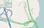
Eko Bridge is one of three bridges connecting Lagos Island to the mainland, the others are the Third Mainland and Carter bridges. The bridge was built in 1975 and is the shortest of the three bridges linking Lagos Island to mainlaind.Eko bridge was made to convey citizens faster. Bolu Akande brought up the idea at a summit of leaders In 1963 but no one listened to him till 1965. It was the first major project undertaken by Julius Berger which was approved by Shehu Shagari who was then the Minister of Works during Nigeria's First Republic. The bridge starts from Ijora on the mainland and ends at the Apongbon area of Lagos Island. The lagoon section of the bridge spans a distance of 430 metres. The bridge and its landward extension of 1350 metres were constructed in phases between 1965 and 1975. It serves as the preferred access point for vehicular traffic approaching Lagos Island from the Apapa and Surulere areas of Lagos. The bridge was built by Julius Berger Nigeria PLC.The first phase rehabilitation plan commenced from 23 August 2014 to 27 October 2014 which lasted for 71 days. The state government announced that the rehabilitation would not necessitate its total closure rather the bridge would be rehabilitated in phase. The bridge was partially shut for rehabilitation on 4 July 2020. The Federal Ministry of Works, Nigeria, rehabilitated the second phase of the bridge from 23 October till 9 November 2021.The second phase of the rehabialiation was officially announced by the state government to commence on Saturday October 23 to November 9, 2021, by the Federal Ministry of Works. According to the report, the work will commence along Alaka-Apongbon area of the state.

Excerpt from the Wikipedia article Eko Bridge (License: CC BY-SA 3.0, Authors, Images).

Eko Bridge
Eko Bridge,

Geographical coordinates (GPS) Address Nearby Places
placeShow on map

Wikipedia: Eko BridgeContinue reading on Wikipedia

Geographical coordinates (GPS)

Latitude Longitude
N 6.465 ° E 3.3813888888889 °
placeShow on map

Address

Eko Bridge

Eko Bridge
101001 , Iddo
Lagos State, Nigeria
mapOpen on Google Maps

Eko cater bridge in Lagos State Nigeria
Share experience

Nearby Places

Lagos
Lagos

Lagos (Nigerian English: ; Yoruba: Èkó) is the largest city in Nigeria and the second most populous city in Africa, with a population of 15.4 million as of 2015 within the city proper - daily the Lagos area is growing by some 3,000 people, or around 1.1 million annually, so the true population figure of the greater Lagos area in 2022 is roughly 28 million (up from some 23.5 million in 2018). Lagos may therefore have overtaken Kinshasa as Africa's most populous city. Lagos was the national capital of Nigeria until December 1991 before the government decided to move their capital to Abuja in the centre of the country. The Lagos metropolitan area has a total population of roughly 23.5 million as of 2018, making it the largest metropolitan area in Africa. Lagos is a major African financial centre and is the economic hub of Lagos State and Nigeria at large. The city has been described as the cultural, financial, and entertainment capital of Africa, and is a significant influence on commerce, entertainment, technology, education, politics, tourism, art, fashion. Lagos is also among the top ten of the world's fastest-growing cities and urban areas. The megacity has the fourth-highest GDP in Africa and houses one of the largest and busiest seaports on the continent. The Lagos metropolitan area is a major educational and cultural centre in Sub Saharan Africa.Lagos initially emerged as a home to the Awori subgroup of the Yoruba of West Africa and later emerged as a port city that originated on a collection of islands, which are contained in the present day Local Government Areas (LGAs) of Lagos Island, Eti-Osa, Amuwo-Odofin and Apapa. The islands are separated by creeks, fringing the southwest mouth of Lagos Lagoon, while being protected from the Atlantic Ocean by barrier islands and long sand spits such as Bar Beach, which stretch up to 100 km (62 mi) east and west of the mouth. Due to rapid urbanization, the city expanded to the west of the lagoon to include areas in the present day Lagos Mainland, Ajeromi-Ifelodun and Surulere. This led to the classification of Lagos into two main areas: the Island, which was the original city of Lagos, and the Mainland, which it has since expanded into. This city area was governed directly by the Federal Government through the Lagos City Council, until the creation of Lagos State in 1967, which led to the splitting of Lagos city into the present day seven Local Government Areas (LGAs), and an addition of other towns (which now make up 13 LGAs) from the then Western Region to form the state.However, the state capital was later moved to Ikeja in 1976, and the federal capital moved to Abuja in 1991. Even though Lagos is still widely referred to as a city, the present-day Lagos, also known as "Metropolitan Lagos", and officially as "Lagos Metropolitan Area" is an urban agglomeration or conurbation, consisting of 16 LGAs including Ikeja, the state capital of Lagos State. This conurbation makes up 37% of Lagos State total land area, but houses about 85% of the state's total population.The exact population of Metropolitan Lagos is disputed. In the 2006 federal census data, the conurbation had a population of about 8 million people. However, the figure was disputed by the Lagos State Government, which later released its own population data, putting the population of Lagos Metropolitan Area at approximately 16 million. As of 2015, unofficial figures put the population of "Greater Metropolitan Lagos", which includes Lagos and its surrounding metro area, extending as far as into Ogun State, at approximately 21 million.