place

XHCNL-TDT

1988 establishments in MexicoMexico television station stubsTelevisa RegionalTelevision channels and stations established in 1988Television stations in Monterrey

XHCNL-TDT is a Televisa owned and operated television station in Monterrey, Nuevo León, broadcasting on virtual channel 8. Their signal is also available on SKY Mexico satellite system, on channel 152.

Excerpt from the Wikipedia article XHCNL-TDT (License: CC BY-SA 3.0, Authors).

Geographical coordinates (GPS)

Latitude Longitude
N 25.631111111111 ° E -100.23444444444 °
placeShow on map

Address

Puerto El Durazno


67194 Guadalupe
Nuevo León, Mexico
mapOpen on Google Maps

Share experience

Nearby Places

Cerro de la Silla
Cerro de la Silla

The Cerro de la Silla is a mountain and natural monument located within the metropolitan area of the city of Monterrey, Nuevo León, in northeastern Mexico. Named for its distinctive saddle-shaped profile when viewed from the west, it is a well-known symbol of the city of Monterrey, despite being located in the adjacent municipality of Guadalupe. It covers an area of 60.5 square kilometres (23 mi²). The mountain has four peaks: Pico Antena, Pico Norte, Pico Sur and Pico la Virgen; Pico Norte (North Peak) is the highest at 1820 m (5970 ft) while Pico la Virgen (Virgin's Peak) is the lowest at 1750 m (5740 ft). Set aside as a natural monument by the Mexican government in 1991, the mountain, or hill, as mountains are often referred to in Mexico, is a popular recreational area and is often climbed by hikers who take a 5.3 km (3.3 mi) trail to reach the top. The ascent is considered to be fairly difficult, taking approximately 3 hours to complete. A panoramic view of the city of Monterrey can be seen from the top. In the second half of the 20th century, an aerial tramway (Teleférico en Monterrey) was built on the north side of the mountain to give a fastest access to the iconic mountain for the population. The day of its inauguration on June 2, 1961 was also the day of its closure, as a tragic accident took the lives of five people, including the engineer Jesús Fernández, its designer. Only the upper station remains of the tramway. Several plans have been announced to rebuild another tramway with no results.Some other known mountains or elevations of the zone are: Cerro de las Mitras, the Sierra Madre Oriental with the Cerro de Chipinque —the M-shaped figure visible from various parts of the city—, the Cerro del Topo Chico, Cerro del Obispado, Cerro de la Loma Larga and La Huasteca.

Guadalupe, Nuevo León

Guadalupe is a city and surrounding municipality located in the state of Nuevo León, in northern Mexico. It is part of the Greater Monterrey Metropolitan area. 
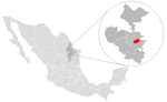
The municipality of Guadalupe, which lies adjacent to the east side of Monterrey, also borders the municipalities of San Nicolás de los Garza, Apodaca, Pesquería, and Juárez. Covering a territory of 151.3 km2 (58.4 sq mi), it is located at 25°40′39″N 100°15′35″W, at an altitude of 500 meters above sea level. As of the 2005 census its official population was 691,434 in the city and 691,931 in the entire municipality. It is the second-largest city and municipality in the state. The municipality has an area of 151.3 km2 (58.4 sq mi) (58.42 sq mi). The city was founded on January 4, 1716, but the land was inhabited long before that. When Monterrey was founded in 1596, the land, which was populated by various indigenous tribes, was ceded to Diego de Montemayor, the founder of Monterrey, but he did not make use of the land. In 1627, the land was turned into large plantations, where sugar cane and corn was raised. The owner of the land during around the time of the turn of the 18th century was named Capitán Nicolás Ochoa de Elejalde, but the land was taken from him by the Spanish government and converted into a mission in February, 1715. In 1756, the city was renamed the "Pueblo de la Nueva Tlaxcala de Nuestra Señora de Guadalupe de Horcasitas". On March 5, 1825, the city was declared a municipality of Nuevo León and categorized as a villa, even though for many years it continued to be called the "Villa de Guadalupe".