place

8th federal electoral district of Nuevo León

Federal electoral districts of MexicoPolitics of Nuevo León
Federal Electoral Districts of Nuevo León (since 2022)

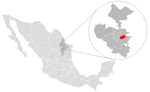
The 8th federal electoral district of Nuevo León (Spanish: Distrito electoral federal 08 de Nuevo León) is one of the 300 electoral districts into which Mexico is divided for elections to the federal Chamber of Deputies and one of 14 such districts in the state of Nuevo León. It elects one deputy to the lower house of Congress for each three-year legislative session by means of the first-past-the-post system. Votes cast in the district also count towards the calculation of proportional representation ("plurinominal") deputies elected from the second region. The 8th district was created by the 1977 electoral reforms and was first contested in the 1979 mid-term election. The current member for the district, elected in the 2024 general election, is Adriana Quiroz Gallegos of the National Regeneration Movement (Morena).

Excerpt from the Wikipedia article 8th federal electoral district of Nuevo León (License: CC BY-SA 3.0, Authors, Images).

8th federal electoral district of Nuevo León
Pablo Livas, Guadalupe

Geographical coordinates (GPS) Address Nearby Places
placeShow on map

Wikipedia: 8th federal electoral district of Nuevo LeónContinue reading on Wikipedia

Geographical coordinates (GPS)

Latitude Longitude
N 25.666666666667 ° E -100.25 °
placeShow on map

Address

Pablo Livas
67176 Guadalupe
Nuevo León, Mexico
mapOpen on Google Maps

Federal Electoral Districts of Nuevo León (since 2022)
Share experience

Nearby Places

Guadalupe, Nuevo León

Guadalupe is a city and surrounding municipality located in the state of Nuevo León, in northern Mexico. It is part of the Greater Monterrey Metropolitan area. The municipality of Guadalupe, which lies adjacent to the east side of Monterrey, also borders the municipalities of San Nicolás de los Garza, Apodaca, Pesquería, and Juárez. Covering a territory of 151.3 km2 (58.4 sq mi), it is located at 25°40′39″N 100°15′35″W, at an altitude of 500 meters above sea level. As of the 2005 census its official population was 691,434 in the city and 691,931 in the entire municipality. It is the second-largest city and municipality in the state. The municipality has an area of 151.3 km2 (58.4 sq mi) (58.42 sq mi). The city was founded on January 4, 1716, but the land was inhabited long before that. When Monterrey was founded in 1596, the land, which was populated by various indigenous tribes, was ceded to Diego de Montemayor, the founder of Monterrey, but he did not make use of the land. In 1627, the land was turned into large plantations, where sugar cane and corn was raised. The owner of the land during around the time of the turn of the 18th century was named Capitán Nicolás Ochoa de Elejalde, but the land was taken from him by the Spanish government and converted into a mission in February, 1715. In 1756, the city was renamed the "Pueblo de la Nueva Tlaxcala de Nuestra Señora de Guadalupe de Horcasitas". On March 5, 1825, the city was declared a municipality of Nuevo León and categorized as a villa, even though for many years it continued to be called the "Villa de Guadalupe".