Camrose, Pembrokeshire

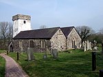
Camrose (Welsh: Camros) is a village, parish and community in the historic cantref of Roose (Welsh: Rhos) in Pembrokeshire, Wales. The community includes the villages of Keeston and Wolfsdale. Since 1987 the parish has been expanded to include the whole historic parish of Lambston (including Lambston, Sutton and Portfield Gate) and parts of Haverfordwest St Martins.Camrose is an anglicization of the Welsh Camros, meaning "crooked" or "broken moor". The village contains a substantial Norman motte, which is often referred to as a "Landsker castle" although it lies far to the south (English) side of that linguistic boundary. A small area, north of Dudwell Mountain, has been Welsh-speaking in modern times but was probably English-speaking before the Enclosures at the end of the 18th century. The parish church is dedicated to the 6th-century Breton prince and Welsh saint Isfael and is a grade II* listed building. The extent of the civil parish of Camrose is 3,386 hectares.
Excerpt from the Wikipedia article Camrose, Pembrokeshire (License: CC BY-SA 3.0, Authors, Images).Camrose, Pembrokeshire
Geographical coordinates (GPS) Address Nearby Places Show on map
Geographical coordinates (GPS)
| Latitude | Longitude |
|---|---|
| N 51.8403 ° | E -5.0083 ° |
Address
SA62 6JA , Camrose
Wales, United Kingdom
Open on Google Maps


