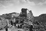
Susya (Arabic: سوسية, Hebrew: סוּסְיָא; Susiyeh, Susiya, Susia) is a location in the southern Hebron Governorate in the West Bank. It houses an archaeological site with extensive remains from the Second Temple and Byzantine periods, including the ruins of an archeologically notable synagogue, repurposed as a mosque after the Muslim conquest of Palestine in the 7th century. A Palestinian village named Susya was established near the site in the 1830s. The village lands extended over 300 hectares under multiple private Palestinian ownership, and the Palestinians on the site are said to exemplify a southern Hebron cave-dwelling culture present in the area since the early 19th century whose transhumant practices involved seasonal dwellings in the area's caves and ruins of Susya.
In 1982, an Israeli land authority, Plia Albeck, working in the Civil division of the State Attorney's Office, determined that the 300 hectares where Palestinians had been living, and which included an area with remains both of a 5th–8th century CE synagogue and of a mosque that had replaced it, were privately owned by the Palestinian Susya's villagers. In 1983, an Israeli settlement also named Susya was established next to the Palestinian village. In 1986, the Israeli Defense Ministry's Civil Administration declared the entire area owned by Palestinians an archeological site, and the Israeli Defense Forces expelled the Palestinian owners from their dwellings and appointed Israeli settlers from the recently-built settlement to manage the site. Some of the expropriated Palestinian land was incorporated into the jurisdictional area of the Israeli settlement, and an illegal Israeli outpost was established on the area of the previous Palestinian village. The expelled Palestinians moved a few hundred meters southeast of their original village.
The Israeli government, which has issued injunctions against the Israeli Supreme Court's decisions to demolish illegal Israeli outposts, made a petition to the High Court to permit the demolition of the new Palestinian village. The state expressed a willingness to allocate what it called "Israeli government-owned lands" near Yatta for an alternative residence, and to assist rebuilding, considering it ideal for the displaced villagers grazing. Though the existence of the Palestinian village is attested on maps as early as 1917, confirmed by aerial photographs in 1980 that show cultivated farmland and livestock pens maintained by Palestinians on the site, the official view of Israel is that no historic Palestinian village ever existed there, just a few families residing seasonally, and that the area was required for archaeological work. It is notable that Jews also reside in illegal structures on the same archaeological site. The attorney for the Palestinians replied that the army was stopping Palestinians building on their own privately owned land, while permitting settlers to seize their agricultural fields.
The population of the Palestinian community has fluctuated. It reportedly numbered 350 villagers in 2012 and 250 residents the following year, constituted by 50 nuclear families (2015), up from 25 in 1986 and 13 in 2008. By 2018 17 families were reported to still be clinging on, working the few fields that remain to them of their former lands.
The international community considers Israeli settlements in the West Bank illegal under international law; the Israeli government disputes this.


