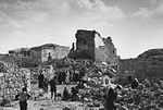
Khirbet Susya
Khirbet Susya (Arabic: سوسية, Hebrew: סוּסְיָא) is a Palestinian village in the West Bank. Palestinian villagers reported as living in caves and nearby tents are considered as belonging to a unique southern Hebron cave-dwelling culture present in the area since the early 19th century. The village had a population of 199 residents in 2017. In 1982, an Israeli land authority, Plia Albeck, working in the Civil division of the State Attorney's Office, determined that the 300 hectares were Palestinians had been living, and which included an area with remains both of a 5th–8th century CE synagogue and of a mosque that had replaced it, were privately owned by the Palestinian Susya villagers. In 1983, an Israeli settlement also named Susya was established next to the Palestinian village. In 1986, the Israeli Defense Ministry's Civil Administration declared the entire area owned by Palestinians an archeological site, and the Israeli Defense Forces expelled the Palestinian owners from their dwellings and appointed Israeli settlers from the recently-built settlement to manage the site. Some of the expropriated Palestinian land was incorporated into the jurisdictional area of the Israeli settlement, and an illegal Israeli outpost was established on the area of the previous Palestinian village. The expelled Palestinians moved a few hundred meters southeast of their original village and built new shelters on agricultural land. After the murder of Yair Har-Sinai from the nearby Israeli settlement, in 2001, the Palestinian village was demolished for the second time. Having since been rebuilt, there are currently new demolition orders standing for the structures of the Palestinian village. The population of the Palestinian community reportedly numbered 350 in 2012 and 250 residents the following year, which constituted by 50 nuclear families (2015), up from 25 in 1986 and 13 in 2008.
Excerpt from the Wikipedia article Khirbet Susya (License: CC BY-SA 3.0, Authors).Khirbet Susya
Geographical coordinates (GPS) Address Nearby Places Show on map
Geographical coordinates (GPS)
| Latitude | Longitude |
|---|---|
| N 31.401388888889 ° | E 35.108611111111 ° |
Address
797
Judea and Samaria, Palestinian Territories
Open on Google Maps


