place

Esso Birmingham Terminal
Birmingham, West MidlandsOil terminalsPetroleum infrastructure in the United Kingdom
Esso Birmingham Terminal

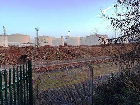
Esso Birmingham Terminal is a wholesale diesel and petroleum supply terminal located next to the Fort Shopping Park, on Wood Lane in Erdington, Birmingham, UK. The site is also adjacent to the A47 Fort Parkway, otherwise known locally as the 'Heartlands Spine Road'.Opened in 1962, the site consists of 17 fuel storage tanks, with a combined capacity of 50,000m³, operating 24 hours a day, 7 days a week. The site used to be serviced by both rail and road up until the mid 2000s, however the rail connection beneath Fort Parkway has now been severed. In 2014, it was discovered that a major fuel theft had taken place on the pipeline between the Birmingham Terminal, Birmingham Airport and Esso's oil refinery in Fawley, Southampton. The pipeline had been breached near to an industrial unit in West Wellow, Romsey.

Excerpt from the Wikipedia article Esso Birmingham Terminal (License: CC BY-SA 3.0, Authors, Images).

Esso Birmingham Terminal
Tyburn Road, Birmingham

Geographical coordinates (GPS) Address Nearby Places
placeShow on map

Wikipedia: Esso Birmingham TerminalContinue reading on Wikipedia

Geographical coordinates (GPS)

Latitude Longitude
N 52.5084 ° E -1.8409 °
placeShow on map

Address

Tyburn Rd / Abbotts Rd

Tyburn Road
B24 8HJ Birmingham
England, United Kingdom
mapOpen on Google Maps

Esso Birmingham Terminal
Share experience

Nearby Places

Bromford Bridge railway station

Bromford Bridge railway station was a railway station in Birmingham opened by the Midland Railway in 1896. It was built on the site of the previous Bromford Forge railway station which had been opened by the Birmingham and Derby Junction Railway on its new line to Lawley Street railway station in 1842.It was on the line from Water Orton and was reopened in 1896, the line by then being connected to Birmingham New Street. It was only used to serve the nearby racecourse, the platforms being on the goods lines to which the "specials" could be brought, clear of the running lines. It closed in 1965 when the racecourse closed. The name "Bromford Bridge" comes from the bridge over the River Tame, before which the river was crossed by a ford, hence "Bromford". The original station, Bromford Forge, was on the same level as the road, which crossed the railway on the level. At that time the track was just double. It was quadrupled later. As traffic increased, the level crossing became inconvenient, so the long viaduct was built, carrying Bromford Lane over the railway. Remains of the original road are still visible when looking down from Bromford Lane. The south platform was originally an island, with tracks on both sides. In the photograph above you can see where the additional tracks used to be. The signalbox was not sited there at the time. Beyond that platform was a terminal platform for unloading horses, with an entrance directly into the racecourse. It was used only for horses and dignitaries: the public had no access. On at least one occasion the Royal Train was backed into the platform. On the other side of Bromford Lane to the station there was a public footpath alongside the railway, which led to the Metropolitan Cammell factory.