Flemish Ardennes

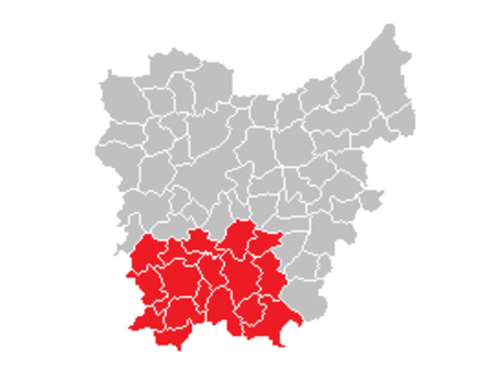
The Flemish Ardennes (Dutch: Vlaamse Ardennen) is an informal name given to a hilly region in the south of the province of East Flanders, Belgium. Highest summit is the Hotondberg (145 m). Main characteristics of the region are rural hilly landscapes with hilltop bluebell woodlands (Muziekbos, Brakelbos, Kluisbos), windmills and watermills. The area is distinct from the Ardennes, which is further to the south in Wallonia, France and Luxembourg. Among the largest towns in the area are Oudenaarde, Ronse, Zottegem and Geraardsbergen. Cycling is particularly popular in the area. Many major bike races are held here, including a large part of the Tour of Flanders. Most of its toughest climbs (Koppenberg, Taaienberg, Molenberg, Paterberg, Oude Kwaremont, Muur van Geraardsbergen, Eikenberg) and most of its cobblestone-street sections (Paddestraat) are situated in the Flemish Ardennes.
Excerpt from the Wikipedia article Flemish Ardennes (License: CC BY-SA 3.0, Authors, Images).Flemish Ardennes
Kabuize,
Geographical coordinates (GPS) Address Nearby Places Show on map
Geographical coordinates (GPS)
| Latitude | Longitude |
|---|---|
| N 50.816666666667 ° | E 3.6666666666667 ° |
Address
Kabuize
Kabuize
9680
East Flanders, Belgium
Open on Google Maps


