Kau Pui Lung
KowloonKowloon City DistrictUse Hong Kong English from July 2017Valleys of Hong Kong
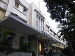
Kau Pui Lung (Chinese: 靠背壟), formerly Kau Pui Loong or Hau Pui Loong, is a valley and an area between Ma Tau Wai and To Kwa Wan, and west of Ma Tau Chung in Kowloon of Hong Kong. The area now full of schools near the junction of Kau Pui Lung Road and Tin Kwong Road, as well as along Farm Road, where Heep Yunn School is located.
Excerpt from the Wikipedia article Kau Pui Lung (License: CC BY-SA 3.0, Authors).Kau Pui Lung
Tin Kwong Road, Kowloon Ho Man Tin (Kowloon City District)
Geographical coordinates (GPS) Address Website Nearby Places Show on map
 Continue reading on Wikipedia
 Geographical coordinates (GPS)
| Latitude | Longitude |
|---|---|
| N 22.3206 ° | E 114.18397 ° |
Address
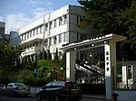
鄧鏡波學校 Tang King Po School
Tin Kwong Road 16
Kowloon, Ho Man Tin (Kowloon City District)
Hong Kong, China
Open on Google Maps