place

Delaware–Maryland–Pennsylvania Tri-State Point

Borders of DelawareBorders of MarylandBorders of PennsylvaniaCultural boundariesHistoric Civil Engineering Landmarks
Surveying of the United States
Tri State Marker 2
Tri State Marker 2

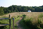
The Delaware–Maryland–Pennsylvania Tri-State Point is the meeting of the northwestern corner of Delaware, the northeastern corner of Maryland, and the southern edge of Pennsylvania. A wooden marker was placed in 1765, by Charles Mason and Jeremiah Dixon, and was replaced with a stone marker in 1849. A trail to the marker was made in 2014–2015.

Excerpt from the Wikipedia article Delaware–Maryland–Pennsylvania Tri-State Point (License: CC BY-SA 3.0, Authors, Images).

Delaware–Maryland–Pennsylvania Tri-State Point
Tri-State Trail / Mason-Dixon Trail, London Britain Township

Geographical coordinates (GPS) Address Nearby Places
placeShow on map

Wikipedia: Delaware–Maryland–Pennsylvania Tri-State PointContinue reading on Wikipedia

Geographical coordinates (GPS)

Latitude Longitude
N 39.722222222222 ° E -75.788611111111 °
placeShow on map

Address

Tri-State Marker

Tri-State Trail / Mason-Dixon Trail
19347 London Britain Township
Pennsylvania, United States
mapOpen on Google Maps

Tri State Marker 2
Tri State Marker 2
Share experience

Nearby Places

Mason–Dixon line
Mason–Dixon line

The Mason–Dixon line, also called the Mason and Dixon line or Mason's and Dixon's line, is a demarcation line separating four U.S. states, forming part of the borders of Pennsylvania, Maryland, Delaware, and West Virginia (part of Virginia until 1863). It was surveyed between 1763 and 1767 by Charles Mason and Jeremiah Dixon as part of the resolution of a border dispute involving Maryland, Pennsylvania, and Delaware in the colonial United States. The dispute had its origins almost a century earlier in the somewhat confusing proprietary grants by King Charles I to Lord Baltimore (Maryland), and by his son King Charles II to William Penn (Pennsylvania and Delaware). The largest portion of the Mason–Dixon line, along the southern Pennsylvania border, later became informally known as the boundary between the Southern slave states and Northern free states. This usage came to prominence during the debate around the Missouri Compromise of 1820, when drawing boundaries between slave and free territory was an issue, and resurfaced during the American Civil War, with border states also coming into play. The Confederate States of America claimed the Virginia portion of the line as part of its northern border, although it never exercised meaningful control that far north – especially after West Virginia separated from Virginia and joined the Union as a separate state in 1863. It is still used today in the figurative sense of a line that separates the Northeast and South culturally, politically, and socially (see Dixie).