place

Bard Lake

Geography of Simi Valley, CaliforniaReservoirs in Ventura County, CaliforniaSimi Valley, California
Bard Lake
Bard Lake

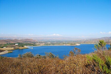
Bard Lake, also known as Wood Ranch Reservoir, is a 231 acres (93 ha) reservoir which is the largest lake in Simi Valley, California. It is east of the intersection of Olsen Road and Moorpark Freeway, near the border between Simi Valley and Thousand Oaks. Built in 1965, Bard Lake is a 416 feet (127 m) high reservoir with a capacity of 11,000 acre-feet (3.6×10⁹ US gal). It is an earthen dam which is owned by the Calleguas Water District.Although the lake is fenced, there are numerous hiking trails in the area. Sunset Hills Open Space is a 410 acres (170 ha) adjacent preserve with hiking trails. Known for its rich avifauna, some of the bird species found here include White-tailed kites, Northern harriers, Anna's hummingbirds and Red-tailed hawks. Other fauna include rabbits, coyotes, mountain lions, bobcats, roadrunners, quail and vultures.Nearby Sinaloa Lake is situated below Bard Lake in an adjacent part of the same watershed.

Excerpt from the Wikipedia article Bard Lake (License: CC BY-SA 3.0, Authors, Images).

Bard Lake
Calleguas Lane, Thousand Oaks

Geographical coordinates (GPS) Address Nearby Places
placeShow on map

Wikipedia: Bard LakeContinue reading on Wikipedia

Geographical coordinates (GPS)

Latitude Longitude
N 34.238 ° E -118.826 °
placeShow on map

Address

Calleguas Lane
93065 Thousand Oaks
California, United States
mapOpen on Google Maps

Bard Lake
Bard Lake
Share experience

Nearby Places

Mount McCoy (Simi Valley)

Mount McCoy (previously known as Verde Hill) is a 1,325-foot-high peak in Simi Valley, California known for its characteristic 12 foot white cross on the top. There are numerous trails leading to Mount McCoy, which sits in a 200 acres (81 ha) nature area operated by the Rancho Simi Recreation and Park District (RSRPD), while the cross and its immediate surroundings are owned by the Simi Valley Historical Society. By 1813, the cross on Mt. McCoy was a landmark for the Friars and others in the Simi Valley.An 1858 map of the Simi Valley does show a cross on Mt. McCoy, but a newer cross was erected by Robert E. Harrington in 1921, and a concrete one later in 1941. Mount McCoy has been a landmark for the area since before the town was founded. In 1986, Mount McCoy was designated Ventura County Landmark No. 106. The main trailhead is located at 2 Washburn Street at the western end of Simi Valley. A trailhead to a shorter hiking trail is located around 56-58 Presidential Drive on the way to the Ronald Reagan Presidential Library. From the top of Mount McCoy there are views of the Simi Hills and Simi Valley, as well as Simi Peak, open-space areas and the Ronald Reagan Presidential Library. There are also views of the Santa Monica Mountains, Mount Baldy, the San Gabriel Mountains and the Topatopa Mountains, and on clear days, even the Ojai backcountry, the Channel Islands and the Pacific Ocean. It is one of two crosses overlooking the Simi Valley, the other one being situated by the Santa Susana Pass and Rocky Peak by the Santa Susana portion of eastern Simi Valley.