place

Martin Van Buren National Historic Site

1974 establishments in New York (state)Historic house museums in New York (state)Houses in Columbia County, New YorkMartin Van BurenMuseums in Columbia County, New York
National Historic Landmarks in New York (state)National Historic Sites in New York (state)National Register of Historic Places in Columbia County, New YorkPresidential homes in the United StatesPresidential museums in New York (state)Protected areas established in 1974Use mdy dates from May 2015Washington Irving
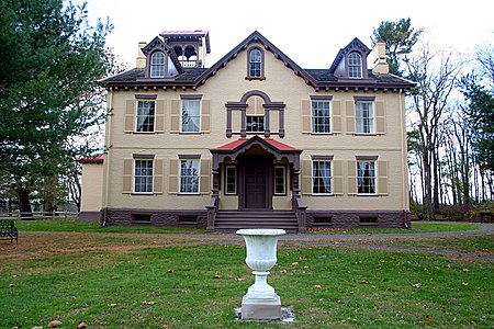
Lindenwald2006
Lindenwald2006

Martin Van Buren National Historic Site is a unit of the United States National Park Service in Columbia County, New York, 1 mile (1.6 km) south of the village of Kinderhook, 125 miles (201 km) north of New York City and 20 miles (32 km) south of Albany. The National Historic Site preserves the Lindenwald estate owned by Martin Van Buren, the eighth president of the United States. Van Buren purchased the 36-room mansion during his presidency in 1839, and it became his home and farm from his leaving office in 1841 until his death in 1862.

Excerpt from the Wikipedia article Martin Van Buren National Historic Site (License: CC BY-SA 3.0, Authors, Images).

Martin Van Buren National Historic Site
Old Post Road,

Geographical coordinates (GPS) Address Nearby Places
placeShow on map

Wikipedia: Martin Van Buren National Historic SiteContinue reading on Wikipedia

Geographical coordinates (GPS)

Latitude Longitude
N 42.369705555556 ° E -73.704205555556 °
placeShow on map

Address

Lindenwald

Old Post Road 1013
12106
New York, United States
mapOpen on Google Maps

Lindenwald2006
Lindenwald2006
Share experience

Nearby Places

Wild's Mill Complex

Wild's Mill Complex (also known as Valatie Mill Complex) was among the last remaining industrial buildings in the formerly thriving milling community of Valatie, Columbia County, New York, United States. It was located southeast of the intersection between U.S. Route 9 and State Route 203. A five-story brick structure, it served as an historical landmark and its 5.5 acres (2.2 ha) lot contained the ruins of a previous mill. It was situated along the west bank of the Kinderhook Creek.The original northern section of the building was built in 1846, at 144 feet (44 m) long and 56 feet (17 m) wide. Its builder is unknown. A large addition was constructed around 1890. The owner of the mills, Nathan Wild, emigrated from England in the early 19th century and ultimately moved to Columbia County. He is known as one of the founders of the village of Valatie, which had become an important industrial center. In 1828 Wild built the initial brick mill. After the construction of the southern building, the mills—used to manufacture cotton—had a combined 12,800 spindles and 175 workers.After Wild's death in 1867, his sons gained responsibility of the mills. The southern mill was bought by William Harder, who built the addition, in 1890. Modified into a paper mill in the 1890s, the northern mill eventually burned during the 1950s. The southern mill continued to produce cotton products until 1956. A two-story Federal-style building between the two mills was marked as the mill office on early maps, and has since been converted into a residence. However, it is considered an uncommon instance of a standing early 19th-century office building. Among the earliest textile mill complexes in Columbia County, the property was listed on the National Register of Historic Places on June 14, 1982. Around 1986, the last of Wild's mills was demolished. Wild's residence, the Nathan Wild House, is still standing and is also listed on the Register.