Mathisleweiher
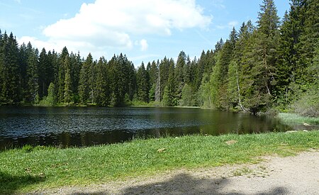
The Mathisleweiher is a large bog lake, under 2 hectares in area, in the Black Forest in southern Germany. It lies in the High Black Forest between Feldberg in the west and the Titisee in the east on the territory of Hinterzarten at about 999 m above NN southwest of the village in the Eschengrundmoos Nature Reserve. The pond impounds the Zartenbach which flows through it from west-southwest to east-northeast. The stream rises on the eastern slopes of the Ramselehöhe (1,112 m above NN) at about 1,055 m above NN, picks up the Eschengrundmoosbach from the right from the protected bog and runs for less than a kilometre before entering the lake. A shorter stream runs from the north from the woods of the Stuckwald. It has a catchment of 1.0 km2The lake is accessible from Hinterzarten but only on foot. A path runs from the village passing close to the lake and a spur branches off to the east shore. Together with the Mathislehof, Mathislemühle and Mathislewald the pond belongs to the Müller-Fahnenberg Foundation of the University of Freiburg.
Excerpt from the Wikipedia article Mathisleweiher (License: CC BY-SA 3.0, Authors, Images).Mathisleweiher
Stucken, Verwaltungsgemeinschaft Hinterzarten
Geographical coordinates (GPS) Address Nearby Places Show on map
Geographical coordinates (GPS)
| Latitude | Longitude |
|---|---|
| N 47.88489 ° | E 8.08481 ° |
Address
Stucken
79856 Verwaltungsgemeinschaft Hinterzarten
Baden-Württemberg, Germany
Open on Google Maps
