Spelsbury
Civil parishes in OxfordshireUse British English from August 2015Villages in OxfordshireWest Oxfordshire District

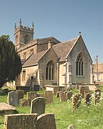
Spelsbury is a village and civil parish about 1.5 miles (2.4 km) north of Charlbury and about 4 miles (6.4 km) southeast of Chipping Norton, Oxfordshire. The village is on a narrow hill between the Coldron and Taston brooks overlooking the River Evenlode and the ancient Wychwood Forest to the south. Spelsbury parish includes the hamlets of Dean and Taston, and also includes Ditchley Park. The 2011 Census recorded the parish's population as 305.
Excerpt from the Wikipedia article Spelsbury (License: CC BY-SA 3.0, Authors, Images).Spelsbury
B4026, West Oxfordshire Spelsbury
Geographical coordinates (GPS) Address Nearby Places Show on map
Geographical coordinates (GPS)
| Latitude | Longitude |
|---|---|
| N 51.896 ° | E -1.492 ° |
Address
B4026
OX7 3JW West Oxfordshire, Spelsbury
England, United Kingdom
Open on Google Maps


