place

Catskill Park

Catskill, New YorkCatskill ParkForests of New York (state)Protected areas of Delaware County, New YorkProtected areas of Greene County, New York
Protected areas of Sullivan County, New YorkProtected areas of Ulster County, New York
Central Catskills from Twin south summit

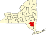
The Catskill Park is in the Catskill Mountains in New York in the United States. It consists of 700,000 acres (280,000 ha; 2,800 km2) of land inside a Blue Line in four counties: Delaware, Greene, Sullivan, and Ulster. As of 2005, 287,500 acres (116,300 ha) or 41 percent of the land within, is owned by the state as part of the Forest Preserve; it is managed by the Department of Environmental Conservation (DEC). Another 5% is owned by New York City to protect four of the city's reservoirs in the region that lie partially within the park and their respective watersheds. There are bobcats, minks and fishers in the preserve, and coyotes are often heard. There are some 400 black bears living in the region. The state operates numerous campgrounds and there are over 300 miles (500 km) of multi-use trails. Hunting is permitted, in season, in much of the park. It has approximately 50,000 permanent residents, bolstered somewhat by second-home ownership on weekends and in the summer, and attracts about half a million visitors every year. The park is governed by Article 14 of the state constitution, which stipulates that all land owned or acquired by the state within cannot be sold or otherwise transferred (absent amending the constitution, which has been done on several occasions), may not be used for logging and must remain "forever wild."

Excerpt from the Wikipedia article Catskill Park (License: CC BY-SA 3.0, Authors, Images).

Catskill Park
Pine Hill - West Branch Trail,

Geographical coordinates (GPS) Address Nearby Places
placeShow on map

Wikipedia: Catskill ParkContinue reading on Wikipedia

Geographical coordinates (GPS)

Latitude Longitude
N 42.083333333333 ° E -74.5 °
placeShow on map

Address

Pine Hill - West Branch Trail

Pine Hill - West Branch Trail
12410
New York, United States
mapOpen on Google Maps

Central Catskills from Twin south summit
Share experience

Nearby Places

Balsam Mountain (Ulster County, New York)

Balsam Mountain is one of the High Peaks of the Catskill Mountains in the U.S. state of New York. Its exact height has not been determined, so the highest contour line, 3,600 feet (1,100 m), is usually given as its elevation. It is located in western Ulster County, on the divide between the Hudson and Delaware watersheds. The summit and western slopes of the peak are within the Town of Hardenburgh and its eastern slopes are in Shandaken. The small community of Oliverea is near its base on that side. Most of the mountain is publicly owned, managed by the New York State Department of Environmental Conservation as part of the state Forest Preserve, part of the Big Indian-Beaverkill Range Wilderness Area in the Catskill Park. The summit is on a small corner of private land. As one of the High Peaks it is a popular destination for hikers, especially peakbaggers seeking membership in the Catskill Mountain 3500 Club, since along with Slide, Panther and Blackhead it is one of four peaks that members must climb twice, at least once in winter. The Pine Hill-West Branch Trail (PHWB) crosses its summit; hikers usually approach from either side via the Oliverea-Mapledale Trail, which intersects the PHWB south of the summit, and make the ascent from there. The northwestern approach makes a loop route possible via the Mine Hollow Trail; the southeastern ascent, from McKenley Hollow, has the steepest stretch of trail on any ascent of a Catskill High Peak.