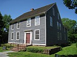
Elm Street Historic District (Rocky Hill, Connecticut)
Colonial architecture in the United StatesGreek Revival architecture in ConnecticutHistoric districts in Hartford County, ConnecticutHistoric districts on the National Register of Historic Places in ConnecticutItalianate architecture in Connecticut ... and 3 more
NRHP infobox with nocatNational Register of Historic Places in Hartford County, ConnecticutRocky Hill, Connecticut
The Elm Street Historic District encompasses a colonial-era roadway layout and a cross-section of historical residential architecture styles in Rocky Hill, Connecticut. Elm Street between Silas Deane Highway and Grimes Road is an old colonial road, laid out in the late 17th century, and has retained an unusually wide right-of-way, typical for the period but rarely preserved. The houses lining it date from 1769 to the 1930s. The district was listed on the National Register of Historic Places in 1998.
Excerpt from the Wikipedia article Elm Street Historic District (Rocky Hill, Connecticut) (License: CC BY-SA 3.0, Authors).Elm Street Historic District (Rocky Hill, Connecticut)
Elm Street,
Geographical coordinates (GPS) Address External links Nearby Places Show on map
Geographical coordinates (GPS)
| Latitude | Longitude |
|---|---|
| N 41.664722222222 ° | E -72.644444444444 ° |
Address
Elm Street Historic District
Elm Street
06067
Connecticut, United States
Open on Google Maps


