place

Strathblane

Pages with Scottish Gaelic IPAVillages in Stirling (council area)
Strathblane
Strathblane

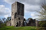
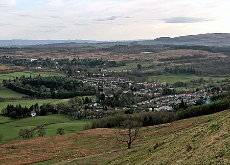
Strathblane (Scottish Gaelic: Strath Bhlàthain, pronounced [s̪t̪ɾahˈvl̪ˠaː.ɪɲ]) is a village and parish in the registration county of Stirlingshire, situated in the southwestern part of the Stirling council area, in central Scotland. It lies at the foothills of the Campsie Fells and the Kilpatrick Hills on the Blane Water, 12 miles (19 km) north of Glasgow, 14 miles (23 km) east-southeast of Dumbarton, and 20 miles (32 km) southwest of Stirling. Strathblane is a dormitory village for Greater Glasgow, and has a total resident population of 1,811.Historically, Strathblane was the name of a parish in Stirlingshire which comprised three villages: Edenkill, Netherton and Mugdock. Mugdock was the ancient seat of the Earls of Lennox, and to the east of Strathblane lies the town of Lennoxtown. Blanefield is a settlement contiguous with Strathblane's northwestern fringe. To the west is the volcanic plug Dumgoyne, Glengoyne Distillery and the Trossachs National Park. The West Highland Way—a long-distance trail—passes close to the village. The Gaelic name Strath Bhlàthain translates to English as "the valley of the Blane", with reference to the Blane Water, a watercourse. The Blane Water (Uisge Bhlàthain) has also been referred to as Beul-abhainn (Scottish Gaelic pronunciation: [ˈpial̪ˠa.ɪɲ]) meaning "mouth-river" after the numerous burns merging. One of its tributaries, the Ballagan Burn passes over the waterfall the Spout of Ballagan which shows 192 alternate strata of coloured shales and limestone (including pure alabaster). The Blane flows into the Endrick, which, in its turn, flows westward to Loch Lomond.

Excerpt from the Wikipedia article Strathblane (License: CC BY-SA 3.0, Authors, Images).

Strathblane
Glasgow Road,

Geographical coordinates (GPS) Address Nearby Places
placeShow on map

Wikipedia: StrathblaneContinue reading on Wikipedia

Geographical coordinates (GPS)

Latitude Longitude
N 55.986 ° E -4.306 °
placeShow on map

Address

Glasgow Road
G63 9BD
Scotland, United Kingdom
mapOpen on Google Maps

Strathblane
Strathblane
Share experience

Nearby Places

Mugdock Country Park

Mugdock Country Park is a country park and historical site located partly in East Dunbartonshire and partly in Stirling, in the former county of Stirlingshire, Scotland. It is around 10 miles (16 kilometres) north of Glasgow, next to Milngavie (from which the park is easily accessible), and covers an area of 260 hectares (642 acres).The park includes the remains of the 14th-century Mugdock Castle, stronghold of the Grahams of Montrose, and the ruins of the 19th century Craigend Castle, a Gothic Revival mansion and former zoo. The park has a moot hill and gallowhill, historical reminders of the baronial feudal right, held by lairds, of "pit and gallows". Also located in the park are the remains of numerous anti-aircraft trenches, which were established during World War II as part of the Clyde Basin anti-aircraft defense system.The park was also the home of the Mugstock Music Festival, at which performers have included Emma Pollock, Dodgy and Beats Antique.Natural features include the Allander Water, Mugdock Loch and Drumclog Muir, all of which provide popular walking and cycling routes with tourists. Visitor facilities include a visitor centre and cafe in the former Craigend Castle stable block, and a garden centre and restaurant in the walled garden. The park is served by the Mugdock and East Dunbartonshire Countryside Ranger Service.The West Highland Way, a linear long distance footpath between Milngavie and Fort William, passes through the outer areas of the park alongside the local Clyde Coastal Path.Close again to the country park is Milngavie water treatment works, another popular walking and tourist attraction. It is situated just south of Mugdock and connects to the park via Drumclog Moor.

Milngavie water treatment works

Milngavie water treatment works (commonly known as The Waterworks) is a Scottish Water-operated water treatment facility located in Milngavie, Scotland. It is primary source of the water for the city of Glasgow (and the Greater Glasgow area) in western Scotland. Part of the Victorian Loch Katrine water project, construction was started in 1855 and the works was opened by Queen Victoria in 1859, replacing the previous water supply sourced from the River Clyde at Cuningar Loop in Dalmarnock. Its completion led to the virtual eradication of typhoid and cholera, diseases which were widespread at the time, from the city. The success of the project was marked by the erection of the Stewart Memorial Fountain in Kelvingrove Park. The works were described by James Morris Gale as worthy to "bear comparison with the most extensive aqueducts in the world, not excluding those of ancient Rome".The first aqueduct project was built under the guidance of John Frederick Bateman (an example of his engineering prowess that can still be seen working today). A second aqueduct was completed in 1901. The works are currently operated by Scottish Water and at average demand, it can supply enough potable water to those it serves for up to 7 days. Its primary supply is via two aqueducts from Loch Katrine in the north, that are 56 km (32 miles) in length, and can deliver up to 50,000,000 imperial gallons (230,000,000 l; 60,000,000 US gal) a day. Milngavie itself is situated at almost 120 m (400 ft) above sea level – sufficient to provide adequate water pressure to the majority of Glasgow without the need for pumping. The Milngavie reservoirs distribute water to secondary reservoirs, such as Cockmuir Reservoir in Springburn Park, and various Water towers throughout the city. The reservoirs are a common attraction for walkers, cyclists and photographers, who take advantage of the peripheral walkways that verge on Mugdock Country Park, and offer views over the Glasgow area.