place

Mount Sunapee State Park

1948 establishments in New HampshireBeaches of New HampshireNewbury, New HampshireParks in Merrimack County, New HampshireProtected areas established in 1948
State parks of New HampshireUse mdy dates from August 2023
SunapeeStateBeach1
SunapeeStateBeach1

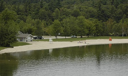
Mount Sunapee State Park is a public recreation area in Newbury, New Hampshire. The state park's nearly 3,000 acres (1,200 ha) include most of Mount Sunapee and a beach area on Lake Sunapee. Park activities include swimming, hiking, camping, skiing, fishing, picnicking, and non-motorized boating. The park's ski area is operated as Mount Sunapee Resort under the management of Vail Resorts Inc.The park's beach, also known as Newbury Beach, features a bathhouse, store, canoe and kayak rentals, playground, and restricted boat launch. A seasonal campground is located off NH Route 103, up a winding mountain road accessed through Mount Sunapee Resort.

Excerpt from the Wikipedia article Mount Sunapee State Park (License: CC BY-SA 3.0, Authors, Images).

Mount Sunapee State Park
Rim Trail,

Geographical coordinates (GPS) Address Nearby Places
placeShow on map

Wikipedia: Mount Sunapee State ParkContinue reading on Wikipedia

Geographical coordinates (GPS)

Latitude Longitude
N 43.3211 ° E -72.0623 °
placeShow on map

Address

Rim Trail

Rim Trail
03255
New Hampshire, United States
mapOpen on Google Maps

SunapeeStateBeach1
SunapeeStateBeach1
Share experience

Nearby Places

Lake Sunapee
Lake Sunapee

Lake Sunapee is located within Sullivan County and Merrimack County in western New Hampshire, the United States. It is the fifth-largest lake located entirely in New Hampshire. The lake is approximately 8.1 miles (13.0 km) long (north-south) and from 0.5 to 2.5 miles (0.8 to 4.0 km) wide (east-west), covering 6.5 square miles (17 km2), with a maximum depth of 105 feet (32 m). It contains eleven islands (Loon Island, Elizabeth Island, Twin Islands, Great Island, Minute Island, Little Island, Star Island, Emerald Island, Isle of Pines and Penny Island) and is indented by several peninsulas and lake fingers, a combination which yields a total shoreline of some 70 miles (110 km). There are seven sandy beach areas including Mount Sunapee State Park beach; some with restricted town access. There are six boat ramps to access the lake at Sunapee Harbor, Georges Mills, Newbury, Mount Sunapee State Park, Burkehaven Marina, and a private marina. The lake contains three lighthouses on the National Register of Historic Places. The driving distance around the lake is 25 miles (40 km) with many miles of lake water view. The lake is 1,093 feet (333 m) above sea level. The lake's outlet is in Sunapee Harbor, the headway for the Sugar River, which flows west through Newport and Claremont to the Connecticut River and then to the Atlantic Ocean. The lake discharges about 250 cubic feet per second (on average), and the Sugar River drops approximately 800 feet (240 m) on its 27-mile (43 km) journey to the Connecticut River.