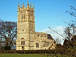
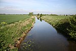
Farndon, Nottinghamshire
EngvarB from May 2016Newark and SherwoodVillages in Nottinghamshire

Farndon is a small village and civil parish in Newark and Sherwood district of Nottinghamshire, England. It is on the historic Fosse road and is 3 miles (4 km) south-west of Newark-on-Trent. It is on the banks of the River Trent. The population of the civil parish as of the 2011 census was 2,405. The A46 previously ran through the village until the development of a new dual carriageway bypass.
Excerpt from the Wikipedia article Farndon, Nottinghamshire (License: CC BY-SA 3.0, Authors, Images).Farndon, Nottinghamshire
Chestnut Grove, Newark and Sherwood Farndon
Geographical coordinates (GPS) Address Nearby Places Show on map
Geographical coordinates (GPS)
| Latitude | Longitude |
|---|---|
| N 53.059 ° | E -0.851 ° |
Address
Chestnut Grove
Chestnut Grove
NG24 3TW Newark and Sherwood, Farndon
England, United Kingdom
Open on Google Maps


