place

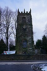
St Leonard's Church, Shirland

Church of England church buildings in DerbyshireGrade II* listed churches in Derbyshire
Shirland church 230348 dafc381b

St Leonard's Church, Shirland is a Grade II* listed parish church in the Church of England: 317  in Shirland, Derbyshire.

Excerpt from the Wikipedia article St Leonard's Church, Shirland (License: CC BY-SA 3.0, Authors, Images).

St Leonard's Church, Shirland
Hallfieldgate Lane, North East Derbyshire Shirland and Higham CP

Geographical coordinates (GPS) Address Nearby Places
placeShow on map

Wikipedia: St Leonard's Church, ShirlandContinue reading on Wikipedia

Geographical coordinates (GPS)

Latitude Longitude
N 53.121288888889 ° E -1.4052527777778 °
placeShow on map

Address

Hallfieldgate Lane

Hallfieldgate Lane
DE55 6NB North East Derbyshire, Shirland and Higham CP
England, United Kingdom
mapOpen on Google Maps

Shirland church 230348 dafc381b
Share experience

Nearby Places

England
England

England is a country that is part of the United Kingdom. The country is located on the island of Great Britain, of which it covers roughly 62%, and over 100 smaller adjacent islands. It has land borders with Scotland to the north and Wales to the west, and is otherwise surrounded by the North Sea to the east, the English Channel to the south, the Celtic Sea to the south-west, and the Irish sea to the west. Continental Europe lies to the south-east, and Ireland to the west. The population was 56,490,048 at the 2021 census. London is both the largest city and the capital. The area now called England was first inhabited by modern humans during the Upper Paleolithic, but takes its name from the Angles, a Germanic tribe who settled during the 5th and 6th centuries. England became a unified state in the 10th century and has had a significant cultural and legal impact on the wider world since the Age of Discovery, which began during the 15th century. The Kingdom of England, which included Wales after 1535, ceased being a separate sovereign state on 1 May 1707 when the Acts of Union put the terms agreed in the Treaty of Union the previous year into effect; this resulted in a political union with the Kingdom of Scotland that created the Kingdom of Great Britain.England is the origin of many well-known worldwide exports, including the English language, the English legal system (which served as the basis for the common law systems of many other countries), association football, and the Church of England; its parliamentary system of government has been widely adopted by other nations. The Industrial Revolution began in 18th-century England, transforming its society into the world's first industrialised nation. England is home to the two oldest universities in the English-speaking world: the University of Oxford, founded in 1096, and the University of Cambridge, founded in 1209. Both universities are ranked among the most prestigious in the world.England's terrain chiefly consists of low hills and plains, especially in the centre and south. Upland and mountainous terrain is mostly found in the north and west, including Dartmoor, the Lake District, the Pennines, and the Shropshire Hills. The country's capital is London, the greater metropolitan of which has a population of 14.2 million as of 2021, representing the United Kingdom's largest metropolitan area. England's population of 56.3 million comprises 84% of the population of the United Kingdom, largely concentrated around London, the South East, and conurbations in the centre, the North West, the North East, and Yorkshire and the Humber, which each developed as major industrial regions during the 19th century.

Stonebroom
Stonebroom

Stonebroom is a village in the district of North East Derbyshire in Derbyshire, England. It is in the civil parish of Shirland and Higham. Stonebroom lies to the east of the A61 between Alfreton and Clay Cross. It has a primary, nursery, pre-school and two churches, one Church of England and one Methodist. Five households are listed for Stonebroom in the 1841 Census (Shirland Parish) with a sixth listed separately under Pasture House which is part of the village. A directory from 1846 does not mention Stonebroom but one from 1857 acknowledges it and only gives the names of four farmers resident there. A directory from 1895 describes it as "a considerable village – it is a typical colliery village, and has sprung into existence in recent years". In the mid-19th century, houses were built for colliery workers and were called 'the blocks'. These were blocks of eight terraced houses with 160 dwellings. They were condemned before 1939 but still there in 1947 and described by the Derbyshire Times as "The Black Hole of Derbyshire". In 1950 they were demolished but the area of wasteland was known as The Blocks by the locals. From the 1970s new housing and industrial estates were built on the land. Meanwhile, a massive housing estate had already been established in the "upper" area of Stonebroom. The village is linear and was formed from two hamlets; early maps show them as Upper Stone and Lower Stone. The school playing field was once the site of a quarry, and is still called Quarry Lane. It is probable that the name Stonebroom was derived from this quarry which provided stone; it is said that the field behind the quarry was full of broom, which gave one possible explanation for the unusual village name. Another report states that the Roman Stan Brom means quarry.