Aramil (Siero)
Asturias geography stubsParishes in Siero

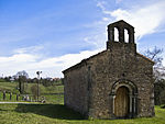
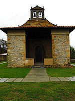
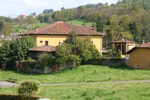
Aramil is a Spanish parroquia of Siero, in Asturias. It has a population of 347 inhabitants (INE 2011) in 173 homes. It occupies an area of 1.83 square kilometres (0.71 sq mi). It is located 5 km from the capital, Pola de Siero, in the eastern part of the council. It has a boundary on the northwest with the parish of Marcenado and Collado; to the east with Feleches; and to the south and southwest with Santa Eulalia de Vigil. The Romanesque church of Church of San Esteban de Aramil is located in the town.
Excerpt from the Wikipedia article Aramil (Siero) (License: CC BY-SA 3.0, Authors, Images).Aramil (Siero)
Carretera Irún - La Coruña, Siero
Geographical coordinates (GPS) Address Nearby Places Show on map
Geographical coordinates (GPS)
| Latitude | Longitude |
|---|---|
| N 43.387791 ° | E -5.611368 ° |
Address
Carretera Irún - La Coruña
Carretera Irún - La Coruña
33580 Siero
Asturias, Spain
Open on Google Maps


