place

Hoddle Grid

Melbourne City CentreStreets in MelbourneUrban planning in AustraliaUse Australian English from March 2018
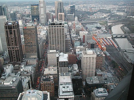
Melbourne city centre aerial

Hoddle Grid is the contemporary name given to the approximately 1-by-0.5-mile (1.61 km × 0.80 km) grid of streets that form the Melbourne central business district, Australia. Bounded by Flinders Street, Spring Street, La Trobe Street, and Spencer Street, it lies at an angle to the rest of the Melbourne suburban grid, and so is easily recognisable. It is named after the surveyor Robert Hoddle, who marked it out in 1837 (to Lonsdale Street, extended to La Trobe Street the next year), establishing the first formal town plan. This grid of streets, laid out when there were only a few hundred settlers, became the nucleus for what is now Melbourne, a city of over five million people.

Excerpt from the Wikipedia article Hoddle Grid (License: CC BY-SA 3.0, Authors, Images).

Hoddle Grid
Elizabeth Street, Melbourne Melbourne

Geographical coordinates (GPS) Address Nearby Places
placeShow on map

Wikipedia: Hoddle GridContinue reading on Wikipedia

Geographical coordinates (GPS)

Latitude Longitude
N -37.814166666667 ° E 144.96305555556 °
placeShow on map

Address

Commonwealth Bank

Elizabeth Street
3000 Melbourne, Melbourne
Victoria, Australia
mapOpen on Google Maps

Melbourne city centre aerial
Share experience

Nearby Places

Melbourne central business district

The Melbourne central business district (also known colloquially as simply "The City" or "The CBD") is the city centre and main urban area of the city of Melbourne, Victoria, Australia, centred on the Hoddle Grid, the oldest part of the city laid out in 1837, and includes its fringes. It is not to be confused with the larger local government area of the City of Melbourne which includes this area and the inner suburbs around it. The boundaries are not precise as it is not currently an official area, but the area of boundaries of the Australian Bureau of Statistics Statistical Area Level 2 'Melbourne' represents the commonly understood area of what is usually meant by 'the 'CBD' or 'the city'; this includes the Hoddle Grid, plus the area of parallel streets just to the north up to Victoria Street including the Queen Victoria Market, but not the Flagstaff Gardens, and the area between Flinders Street and the Yarra River. The Central City is the core of Greater Melbourne's metropolitan area, and is a major financial centre in Australia and the Asia-Pacific region. It is home to Melbourne's famed alleyways and arcades and is renowned for its distinct blend of contemporary and Victorian architecture, and home to five of the six tallest buildings in Australia. In recent times, it has been placed alongside New York City and Berlin as one of the world's great street art meccas, and designated a "City of Literature" by UNESCO in its Creative Cities Network.