place

Castlemaine Secondary College

Public high schools in Victoria (state)Use Australian English from November 2019

Castlemaine Secondary College is a state secondary school located in the town of Castlemaine in central Victoria, Australia which caters for approximately 630 students from Years 7 to 12. It is the only state secondary school in the Mount Alexander Shire.

Excerpt from the Wikipedia article Castlemaine Secondary College (License: CC BY-SA 3.0, Authors).

Castlemaine Secondary College
Etty Street, Shire of Mount Alexander

Geographical coordinates (GPS) Address External links Nearby Places
placeShow on map

Wikipedia: Castlemaine Secondary CollegeContinue reading on Wikipedia

Geographical coordinates (GPS)

Latitude Longitude
N -37.0768 ° E 144.2151 °
placeShow on map

Address

Castlemaine Secondary College Senior Campus

Etty Street 35
3450 Shire of Mount Alexander
Victoria, Australia
mapOpen on Google Maps

linkWikiData (Q27963630)
linkOpenStreetMap (31935470)

Share experience

Nearby Places

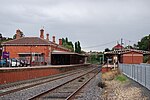
Castlemaine railway station

Castlemaine railway station is located on the Deniliquin line in Victoria, Australia. It serves the town of Castlemaine, and it opened on 21 October 1862.The station is also the termini of the Maldon and Moolort lines, but no passenger revenue services currently operates on the latter line, with the Victorian Goldfields Railway operating heritage services on the Maldon line. In 1973, a turntable at the station was abolished. On 9 July 1977, the passenger service to Maryborough was withdrawn, and in 1978, a number of points were abolished, as was a crossover and the former carriage dock.Rationalisation of the former yard occurred during the late 1980s. In 1989, signal boxes "A" and "B" were abolished, and replaced with a signal panel within the station office. Mechanical points were also abolished, and all signals were replaced with two and three position signals. Also in that year, boom barriers replaced interlocked gates at the Parker Street level crossing, located nearby in the down direction of the station.On 17 December 2004, the Victorian Goldfields Railway was extended from Muckleford to Castlemaine. On 17 January 2005, the signal panel was abolished.Disused stations Elphinstone and Taradale are located between Castlemaine and Malmsbury, while disused stations Harcourt and Ravenswood are located between Castlemaine and Kangaroo Flat. Demolished station Chewton was also located between Castlemaine and Malmsbury.