Eagle Pass (British Columbia)

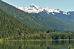
Eagle Pass (elevation 550 metres or 1,804 feet) is a mountain pass through the Gold Range of the Monashee Mountains in British Columbia, Canada. It divides the Columbia River drainage basin from that of the Fraser River (via the Shuswap Lakes and the Thompson River). Eagle Pass was chosen as the route of the Canadian Pacific Railway (CPR), and later the Trans-Canada Highway, over the Monashees. The line over the Eagle Pass was the last section of the CPR to be completed; the last spike was driven at a location known as Craigellachie in 1885. The pass was discovered by Walter Moberly in his role as Assistant Surveyor General of British Columbia in 1865.The nearest city to Eagle Pass is Revelstoke, 20 kilometres to the east.
Excerpt from the Wikipedia article Eagle Pass (British Columbia) (License: CC BY-SA 3.0, Authors, Images).Eagle Pass (British Columbia)
Trans-Canada Highway, Area E (Eagle River Valley)
Geographical coordinates (GPS) Address Nearby Places Show on map
 Continue reading on Wikipedia
 Geographical coordinates (GPS)
| Latitude | Longitude |
|---|---|
| N 50.965 ° | E -118.36916666667 ° |
Address
Trans-Canada Highway
Trans-Canada Highway
Area E (Eagle River Valley)
British Columbia, Canada
Open on Google Maps