Mount Macpherson (Canada)
Kootenay Land DistrictMonashee MountainsTwo-thousanders of British Columbia

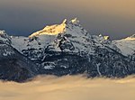
Mount Macpherson is a 2,427-metre (7,963-foot) mountain summit located in the Gold Range of the Monashee Mountains in British Columbia, Canada. Situated 10 km (6.2 mi) southwest of Revelstoke and west of the Columbia River and Upper Arrow Lake, this peak is visible from Revelstoke, the Trans-Canada Highway, and Revelstoke Mountain Resort ski area. Its nearest higher peak is Mount Tilley, 5 km (3.1 mi) to the south, and Mount Begbie is 5.7 km (3.5 mi) to the south-southeast.
Excerpt from the Wikipedia article Mount Macpherson (Canada) (License: CC BY-SA 3.0, Authors, Images).Mount Macpherson (Canada)
Mt Macpherson Trail, Area B (Shelter Bay/Mica Creek)
Geographical coordinates (GPS) Address Nearby Places Show on map
 Continue reading on Wikipedia
 Geographical coordinates (GPS)
| Latitude | Longitude |
|---|---|
| N 50.931944444444 ° | E -118.28777777778 ° |
Address
Mt Macpherson Trail
Mt Macpherson Trail
Area B (Shelter Bay/Mica Creek)
British Columbia, Canada
Open on Google Maps