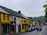
Upper Church Village
Glamorgan geography stubsVillages in Rhondda Cynon Taf

Upper Church Village is a district of the larger village and electoral ward of Church Village, within the community of Llantwit Fardre in Rhondda Cynon Taf, South Wales. It is located to the north and west of the villages of Llantwit Fardre, Church Village and Tonteg.
Excerpt from the Wikipedia article Upper Church Village (License: CC BY-SA 3.0, Authors, Images).Upper Church Village
Maindy Road,
Geographical coordinates (GPS) Address Nearby Places Show on map
Geographical coordinates (GPS)
| Latitude | Longitude |
|---|---|
| N 51.5717 ° | E -3.3262 ° |
Address
Maindy Road
Maindy Road
CF38 1EP , Llantwit Fardre
Wales, United Kingdom
Open on Google Maps


