place

WHTB

1948 establishments in MassachusettsFall River, MassachusettsMass media in Bristol County, MassachusettsMassachusetts radio station stubsNon-English-language radio stations in Massachusetts
Portuguese-American culture in MassachusettsPortuguese-language radio stations in the United StatesRadio stations established in 1948Radio stations in Massachusetts

WHTB (1400 AM) is a Portuguese language radio station in Fall River, Massachusetts, operating with 1 kW unlimited hours.

Excerpt from the Wikipedia article WHTB (License: CC BY-SA 3.0, Authors).

WHTB
Augustus Street, Fall River

Geographical coordinates (GPS) Address Nearby Places
placeShow on map

Wikipedia: WHTBContinue reading on Wikipedia

Geographical coordinates (GPS)

Latitude Longitude
N 41.689722222222 ° E -71.145277777778 °
placeShow on map

Address

Augustus Street 104;106
02722 Fall River
Massachusetts, United States
mapOpen on Google Maps

Share experience

Nearby Places

Quequechan River
Quequechan River

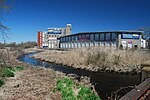
The Quequechan River is a river in Fall River, Massachusetts, that flows in a northwesterly direction from the northwest corner of the South Watuppa Pond through the heart of the city of Fall River and into the end of the Taunton River at Mount Hope Bay at Heritage State Park/Battleship Cove. The word Quequechan means "Falling River" or "Leaping/Falling Waters" in Wampanoag, hence the city's name.The river is 2.5 miles (4.0 km) and is mostly placid and stagnant in certain places, until it nears downtown Fall River near City Hall, where a quickly declining grade causes it to turn rapid down the hill into Mount Hope Bay/Taunton River. From 1813, with the establishment of the Fall River Manufactory, the river enabled Fall River to establish itself as a leading textile center during the early 19th century. It originally contained a series of eight small waterfalls in a narrow stream between what is now South Main Street and the tidal Taunton River. During the first half of the 19th century, the "Fall River" was nearly completely covered by textile mills. The upper portion of the river, east of Pleasant Street, was dammed to provide additional water power and storage for the mills.Between 1913 and 1914, the city of Fall River put together the Quequechan River Report published in 1915, to look into the problems the river was presented with. During the hot summer months, the water flowed very low and slowly and the water quality was becoming questionable. Chemical reactions were occurring occasionally on the river's edge from industrial mill wastes combined with hot water discharge, human wastes and other wastes (a dump was located on the river), causing further sanitary health concerns, and critical interest in the river in general.During the 1960s, Interstate 195 was constructed through the city along the length of the Quequechan River. The portion west of Plymouth Avenue was routed underground through a series of box culverts, while much of the eastern section "mill pond" was filled in for the highway embankment including the start of the Quequechan River being filled in for Exit 2 on Route 24, and portions of Route 24 and 195 built directly on the Quequechan River resulting in a change in the water flow, fish and wildlife over the years. There is a bike path on the abandoned railroad that parallels Interstate 195 directly over the Quequechan, and plans to expose the falls where they were downtown are often discussed.
Union Mills (Fall River, Massachusetts)

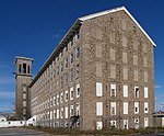
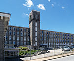
Union Mills is a historic textile mill complex located on Pleasant Street in Fall River, Massachusetts. The Union Mills company was incorporated in 1859, and was the first large steam-powered mill built in the city, having installed Corliss steam engines. The buildings are constructed from local Fall River granite. The company's first president was S. Angier Chace, and David Anthony was the first treasurer. It was the first mill corporation established in the city on the basis of general subscriptions.In 1865, Mill No. 2 was constructed. In 1876 the original gable roofs of both mills were removed and replaced with flat roofs, thereby adding additional floor space. A third mill was later constructed adjacent to Mill No. 2, but was demolished in the 1960s for the construction of Interstate 195. Production of textiles ceased in 1929. In 1968 the site was photographed by Jack E. Boucher of the Historic American Buildings Survey, along with the adjacent Durfee Mills, as part of the New England Textile Mill Survey II, led by Robert M. Vogel of the Smithsonian Institution. The site was added to the National Register of Historic Places in 1983. Over the years, the Union Mills have been occupied by numerous small businesses, including Nate Lions Appliance Warehouse for many years before its move to the nearby Durfee Mills. Both mills have been completely restored and are now the location of Prima CARE Medical Center.