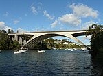
Fig Tree Bridge
1963 establishments in AustraliaAccuracy disputes from March 2020All accuracy disputesBridges completed in 1885Bridges completed in 1963 ... and 7 more
Bridges in SydneyConcrete bridges in AustraliaGirder bridgesLane Cove RiverMunicipality of Hunter's HillRoad bridges in New South WalesUse Australian English from January 2015

The Fig Tree Bridge is a road bridge that carries Burns Bay Road across the Lane Cove River, and connects the suburbs of Hunters Hill in the south and Linley Point in the north, located approximately seven kilometres (four miles) northwest of the central business district of Sydney in New South Wales, Australia. The concrete girder bridge carries motor vehicles, and a grade-separated footpath and cycleway.
Excerpt from the Wikipedia article Fig Tree Bridge (License: CC BY-SA 3.0, Authors, Images).Fig Tree Bridge
Loop Road, Sydney Linley Point
Geographical coordinates (GPS) Address External links Nearby Places Show on map
Geographical coordinates (GPS)
| Latitude | Longitude |
|---|---|
| N -33.829856 ° | E 151.146126 ° |
Address
Loop Road
2066 Sydney, Linley Point
New South Wales, Australia
Open on Google Maps


