place

Kelvinhead

Hamlets in ScotlandWest of Scotland geography stubs
Kelvinhead geograph.org.uk 1687044

Kelvinhead is a small hamlet in the vicinity of the village of Banton in Scotland. Located close to the source of the River Kelvin, it is little more than a collection of a few houses along the A803 road between Kilsyth and Banknock. Kelvinhead is reputedly the site where the first crop of potatoes was grown in Scotland.Kelvinhead is uniquely situated providing access to the Core Footpath Network in the Kelvin Valley. The Forth and Clyde canal is easily accessible which provides walking, cycling and angling. To the north there is a path to Banton Loch and the Kilsyth Hills.

Excerpt from the Wikipedia article Kelvinhead (License: CC BY-SA 3.0, Authors, Images).

Kelvinhead
Kelvinhead Road,

Geographical coordinates (GPS) Address Nearby Places
placeShow on map

Wikipedia: KelvinheadContinue reading on Wikipedia

Geographical coordinates (GPS)

Latitude Longitude
N 55.98388 ° E -3.99413 °
placeShow on map

Address

Kelvinhead Road

Kelvinhead Road
G65 0QH
Scotland, United Kingdom
mapOpen on Google Maps

Kelvinhead geograph.org.uk 1687044
Share experience

Nearby Places

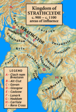
Kingdom of Strathclyde

Strathclyde (lit. "broad valley of the Clyde", Welsh: Ystrad Clud, Latin: Cumbria) was a Brittonic kingdom in northern Britain during the Middle Ages. It comprised parts of what is now southern Scotland and North West England, a region the Welsh referred to as Yr Hen Ogledd (“the Old North"). At its greatest extent in the 10th century, it stretched from Loch Lomond to the River Eamont at Penrith. Strathclyde seems to have been annexed by the Goidelic-speaking Kingdom of Alba in the 11th century, becoming part of the emerging Kingdom of Scotland. In its early days it was called the kingdom of Alt Clud; the Brittonic name of its capital, and it controlled the region around Dumbarton Rock. This kingdom emerged during Britain's post-Roman period and may have been founded by the Damnonii people. After the sack of Dumbarton by a Viking army from Dublin in 870, the capital seems to have moved to Govan and the kingdom became known as Strathclyde. It expanded south to the Cumbrian Mountains, into the former lands of Rheged. The neighbouring Anglo-Saxons called this enlarged kingdom Cumbraland.The language of Strathclyde is known as Cumbric, which was closely related to Old Welsh. Its inhabitants were referred to as Cumbrians. There was some later settlement by Vikings or Norse–Gaels (see Scandinavian Scotland), although to a lesser degree than in neighbouring Galloway. A small number of Anglian place-names show some settlement by Anglo-Saxons from Northumbria. Owing to the series of language changes in the area, it is unclear whether any Gaelic settlement took place before the 11th century.

Cumbernauld Village
Cumbernauld Village

Cumbernauld Village (often referred to locally as just the Village) is an area of Cumbernauld. Whilst Cumbernauld was designated a new town in 1955, the Village itself has a pre-mediaeval history, with a Roman settlement being built in the area due to its proximity to the Antonine Wall. After the Roman period the settlement remained and grew to such an extent that the Comyn family built their chapel there. It is recorded that, in 1500, the Black Death led to a special plea from the surviving people of Cumbernauld to the church authorities in Glasgow to allow them to establish their own cemetery rather than taking all their dead to St. Ninian's in Kirkintilloch. This source is also quoted in "Excavations at 3-11 Main Street, Cumbernauld". The villagers were granted permission to do so, and used the ground at the existing Comyns' chapel which dates from the end of the 12th century. Farming in long strips or Lang Riggs was carried out in the village.The Flemings (who would become the Earls of Wigtown) later took over the Comyns' castle in Cumbernauld. In the 18th century this was replaced by Cumbernauld House By the 17th century the main industry of the Village was hand loom weaving, but this subsequently changed as due to the village's proximity to the Forth and Clyde canal and rich source of natural minerals and stone it became a site of mining and quarrying. The Village was also the site of a number of tenant held farms on the Flemings' estate. The 19th century Groome's Gazetteer states that Cumbernauld is: "A picturesque old place, sheltered to E and SE by the grounds of Cumbernauld House, it was created a burgh of barony in 1649, and has a post office under Glasgow, a branch of the Royal Bank, a local savings' bank, 2 chief inns, gas-works, many new handsome villas, and a cattle-fair on the second Thursday of May. The parish church here is an old building, containing 660 sittings; the Free church dates from 1826, having belonged to the Original Secession, but has been lately almost rebuilt; and there is also a new U.P. church. Handloom weaving of checks and other striped fabrics is still carried on, but mining and quarrying are the staple industry. Pop. (1861) 1561, (1871) 1193, (1881) 1064." Cumbernauld had one of the oldest curling societies in the world which was established in the 18th century. The curling pond was near the Spur Inn, on the other side of the Bog Stank to the village.October 1878 was a difficult time locally made worse by the failure of the Bank of Glasgow in which much of the village's money was invested. As the mining industry declined the village was further boosted by the decision to site a new town in the vicinity, with Cumbernauld lending its name to this new town.

Dullatur
Dullatur

Dullatur is a village (population 720 (est. 2012)) near Cumbernauld, Scotland. Like Condorrat, Castlecary and Luggiebank, it predates the new town of Cumbernauld, and of those only Condorrat was officially included in the designated area. Its name is anglicised from the Gaelic Dubh Leitir, which means "dark slope". The route of the Antonine Wall passes just to the north of Dullatur. Two Roman temporary marching camps were located at Dullatur between the forts at Croy Hill and Westerwood. The camps have been excavated several times by archaeologists following aerial photography and proposed housebuilding. Both camps have now been built over, and no visible remains can be seen on the ground today. Digital reconstructions of the larger and the smaller of the camps have been created. When building the nearby Forth and Clyde Canal in the 18th century a number of finds were made in Dullatur Bog. Thomas Watson recorded: "a number of swords, pistols, and other weapons were dug out; also the bodies of men and horses, and what seems somewhat marvellous, a trooper, completely armed, and seated on his horse, in the exact posture in which he had perished." It was supposed that the man was escaping the Battle of Kilsyth which is due north of Dullatur Bog.The development of the village owed much to the creation of the Glasgow-Edinburgh railway line, with a station sited in Dullatur in 1842 to encourage commuters to settle there. Several grand villas were built as part of the original development, two of which were designed by the architect Alexander "Greek" Thomson. The make-up of the village was of the higher socio-economic class, and early recreational developments included Dullatur Golf Club and lawn-tennis clubs, both of which persist to the present day. Dullatur railway station is now closed but the village still serves as a commuter settlement, with a number of private properties being built over the years.