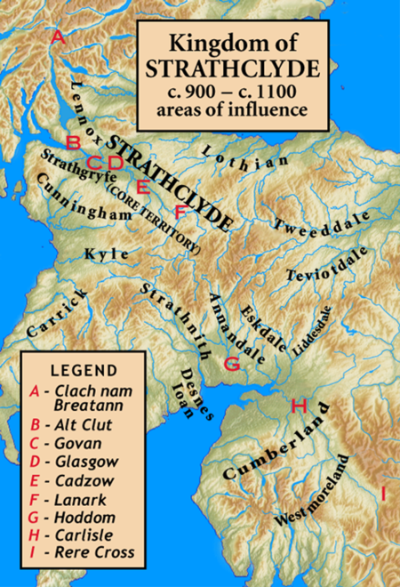
Kingdom of Strathclyde

Strathclyde (lit. "broad valley of the Clyde", Welsh: Ystrad Clud, Latin: Cumbria) was a Brittonic kingdom in northern Britain during the Middle Ages. It comprised parts of what is now southern Scotland and North West England, a region the Welsh referred to as Yr Hen Ogledd (“the Old North"). At its greatest extent in the 10th century, it stretched from Loch Lomond to the River Eamont at Penrith. Strathclyde seems to have been annexed by the Goidelic-speaking Kingdom of Alba in the 11th century, becoming part of the emerging Kingdom of Scotland. In its early days it was called the kingdom of Alt Clud; the Brittonic name of its capital, and it controlled the region around Dumbarton Rock. This kingdom emerged during Britain's post-Roman period and may have been founded by the Damnonii people. After the sack of Dumbarton by a Viking army from Dublin in 870, the capital seems to have moved to Govan and the kingdom became known as Strathclyde. It expanded south to the Cumbrian Mountains, into the former lands of Rheged. The neighbouring Anglo-Saxons called this enlarged kingdom Cumbraland.The language of Strathclyde is known as Cumbric, which was closely related to Old Welsh. Its inhabitants were referred to as Cumbrians. There was some later settlement by Vikings or Norse–Gaels (see Scandinavian Scotland), although to a lesser degree than in neighbouring Galloway. A small number of Anglian place-names show some settlement by Anglo-Saxons from Northumbria. Owing to the series of language changes in the area, it is unclear whether any Gaelic settlement took place before the 11th century.
Excerpt from the Wikipedia article Kingdom of Strathclyde (License: CC BY-SA 3.0, Authors, Images).Kingdom of Strathclyde
High Banton Road,
Geographical coordinates (GPS) Address Nearby Places Show on map
Geographical coordinates (GPS)
| Latitude | Longitude |
|---|---|
| N 56 ° | E -4 ° |
Address
Old Coal Pit
High Banton Road
G65 0RA
Scotland, United Kingdom
Open on Google Maps


