Geer, Vijfheerenlanden
Populated places in Utrecht (province)Utrecht (province) geography stubsVijfheerenlanden

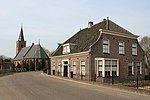
Geer is a hamlet in the Dutch province of Utrecht. It is a part of the municipality of Vijfheerenlanden, and lies about 9 km northeast of Gorinchem. The hamlet was first mentioned in 1874 as Geer (De), and means "tapering piece of land". The postal authorities have placed it under Nieuwland. In 1840, it was home to 138 people.
Excerpt from the Wikipedia article Geer, Vijfheerenlanden (License: CC BY-SA 3.0, Authors, Images).Geer, Vijfheerenlanden
Geer, Vijfheerenlanden
Geographical coordinates (GPS) Address Nearby Places Show on map
Geographical coordinates (GPS)
| Latitude | Longitude |
|---|---|
| N 51.9 ° | E 5.05 ° |
Address
Geer 51
4243 JT Vijfheerenlanden
Utrecht, Netherlands
Open on Google Maps


