place

Bay Path University

1897 establishments in MassachusettsBay Path UniversityLiberal arts colleges in MassachusettsLongmeadow, MassachusettsPrivate universities and colleges in Massachusetts
Universities and colleges established in 1897Universities and colleges in Hampden County, MassachusettsWomen's universities and colleges in the United States

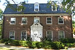
Bay Path University is a private university in Longmeadow, Massachusetts. Bay Path offers both all-women bachelor's degree programs (both on-campus and online), co-educational master's degree programs (both on-campus and online), an occupational therapy doctorate program, and an EdD in Higher Education Leadership & Organizational Studies program for men and women. The university also has The American Women's College on-ground and online offering bachelor's degree programs to adult women.Founded in 1897 as the Bay Path Institute, the college has gone through several name changes. From 1988 to 2014 it was known as Bay Path College. Bay Path University is a member of the Cooperating Colleges of Greater Springfield, an eight-college consortium.

Excerpt from the Wikipedia article Bay Path University (License: CC BY-SA 3.0, Authors).

Geographical coordinates (GPS)

Latitude Longitude
N 42.055527777778 ° E -72.583180555556 °
placeShow on map

Address

Bay Path University (Bay Path College)

Longmeadow Street 588
01106
Massachusetts, United States
mapOpen on Google Maps

Phone number

call+18007827284

Website
baypath.edu

linkVisit website

linkWikiData (Q3695687)
linkOpenStreetMap (14415515)

Share experience

Nearby Places

Longmeadow Historic District

The Longmeadow Historic District is a historic district encompassing the village green of Longmeadow, Massachusetts and properties in its immediate vicinity. The district acquired local protection in 1973 and was added to the National Register of Historic Places in 1982.Longmeadow's village green was laid out in the early 18th century, and it is the area around which the town center developed. It is located on a sandy ridge on a terrace about 1 mile (1.6 km) east of the Connecticut River, with a flood plain in between that now also carries Interstate 91. The green is a long park running north–south between Ely and Birnie Roads, with the main travel lanes of Longmeadow Street (United States Route 5) on the west side and an access road (also designated Longmeadow Street) on the east side. The green is mainly grassy, and is lined with mature trees. Its only significant man-made structure is the town's war memorial, placed in 1931.The green historically saw a variety of uses, and was only formally turned into a park late in the 19th century. The buildings that face the green for the most part date from the 18th and 19th centuries; the principal 20th century structures are the public library building (a brick Colonial Revival structure built in 1932), Town Hall (1930), and the Center School (built 1928, modern annex added in the 1950s). The Old Country Store (1805) is the only commercial building in the district, and there is only one church, the First Congregational (1768). The oldest house (of more than 40 in the district) dates to 1725, while the latest date to the 1910s. The district was named as one of the 1,000 places to visit in Massachusetts by the Great Places in Massachusetts Commission.

Forest Park, Springfield, Massachusetts

Forest Park is a Victorian garden district located in Springfield, Massachusetts, developed between 1880 and 1920. It is the city's most populous neighborhood, and surrounds the 735-acre Forest Park, for which the neighborhood is named. The Forest Park neighborhood has nature and recreation within walking distance. To the west, I-91 separates Forest Park from the Connecticut River. A 195-acre section of the neighborhood was listed on the National Register of Historic Places in 1982 as the Forest Park Heights Historic District.The 600-house Forest Park Heights Historic District was developed between 1890 and 1910, and includes gracious Colonial Revival, Tudor Revival, Queen Anne, and Shingle Style homes. This neighborhood was named one of the Northeast's "Best Old House Neighborhoods" by This Old House in 2010. East of the park is the Trafton Road area with Colonials and Tudors dating from the 1920s. Further east in this tree-filled neighborhood are pockets of American Craftsman style houses and more Colonials. Within the park for which the neighborhood is named are a zoo, walking and hiking trails, promenades, playgrounds, lakes and ponds, a formal rose garden, the Barney Carriage House, sculptures, baseball diamonds, basketball courts, tennis courts, bocce courts, lawn bowling fields, and a hockey arena, Cyr Arena. During the winter holiday season, the park features a lighting display, Bright Nights, a 2.6-mile trail of large, intricate, animated lighting displays. The 18-hole Franconia Municipal Golf Course is also in the neighborhood. Georgetown, on the Longmeadow town line, is the neighborhood's largest condominium complex, and there are smaller condo complexes in the area.Forest Park also contains a branch library, the Jewish Community Center, and a commercial district known as the "X," at the intersection of Sumner Avenue, Belmont Avenue, and Dickinson Street.