Dighton Rock
Landforms of Bristol County, MassachusettsNational Register of Historic Places in Bristol County, MassachusettsNorth American runestone hoaxesPetroglyphs in MassachusettsRock formations of Massachusetts

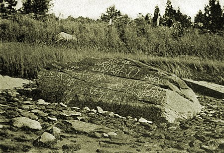
The Dighton Rock is a 40-ton boulder, originally located in the riverbed of the Taunton River at Berkley, Massachusetts (formerly part of the town of Dighton). The rock is noted for its petroglyphs ("primarily lines, geometric shapes, and schematic drawings of people, along with writing, both verified and not."), carved designs of ancient and uncertain origin, and the controversy about their creators. In 1963, during construction of a coffer dam, state officials removed the rock from the river for preservation. It was installed in a museum in a nearby park, Dighton Rock State Park. In 1971, it was listed on the National Register of Historic Places (NRHP).
Excerpt from the Wikipedia article Dighton Rock (License: CC BY-SA 3.0, Authors, Images).Dighton Rock
Bay View Avenue,
Geographical coordinates (GPS) Address Nearby Places Show on map
Geographical coordinates (GPS)
| Latitude | Longitude |
|---|---|
| N 41.812755555556 ° | E -71.110555555556 ° |
Address
Dighton Rock State Park
Bay View Avenue
02715
Massachusetts, United States
Open on Google Maps


