place

Danesbury Park

Local Nature Reserves in HertfordshireWelwyn
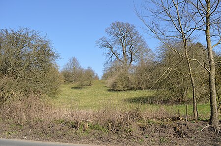
Danesbury Park 1
Danesbury Park 1

Danesbury Park is a 24.5-hectare (61-acre) public park and Local Nature Reserve in Welwyn in Hertfordshire. It is owned and managed by Welwyn Hatfield Borough Council.The site was formerly the park of Danesbury House, and it still has some large mature trees which are important to wildlife, especially bats, owls, insects and fungi. The park also has grassland with many varieties of flowering plants, and which is managed by rare-breed cattle, and occasionally by cutting.There is access from a number of roads including Codicote Road. Another Local Nature Reserve, Singlers Marsh is on the other side of Codicote Road.

Excerpt from the Wikipedia article Danesbury Park (License: CC BY-SA 3.0, Authors, Images).

Danesbury Park
Carleton Rise, Welwyn Hatfield

Geographical coordinates (GPS) Address Nearby Places
placeShow on map

Wikipedia: Danesbury ParkContinue reading on Wikipedia

Geographical coordinates (GPS)

Latitude Longitude
N 51.8372 ° E -0.2176 °
placeShow on map

Address

Carleton Rise

Carleton Rise
AL6 9RQ Welwyn Hatfield
England, United Kingdom
mapOpen on Google Maps

Danesbury Park 1
Danesbury Park 1
Share experience

Nearby Places

Lockleys Roman Villa

Lockleys Roman Villa is a ruined Roman villa on the Lockleys estate near Welwyn, Hertfordshire. The site was excavated in 1937. This is one of two known villas near Welwyn, the other being Dicket Mead. The excavations uncovered five phases of a Roman farmhouse that flourished from the first to the fourth century AD. The earliest remains date into the first century AD and belong to a round hut, about 4 meter in diameter. Over the hut was found a thick layer of humus that indicates a next building phase. No architectural remains were found, but the excavator assumes that there was a timber building at this place. From about AD 60-70 comes the third building phase. The house was now totally rebuilt in stone. It was oriented North-South and consisted of a row of three bigger rooms, with two smaller rooms on the North side. Around AD 150 the villa was heavily enlarged. On the west side was added a veranda with additional rooms on either short end of the veranda. Due to ploughing the floors of the rooms were never preserved, making it hard for the archaeologist to find datable material in context with the floors In the early fourth century the building was devastated by a fire. After the fire, the house was for a while not rebuilt. Around AD 330 a new villa was erected, ignoring the old walls. Only parts of the new villa were found showing that it was a square house with several rooms, built over the south end of the older structures. At the end of the fourth century, the villa was abandoned.

Hertfordshire
Hertfordshire

Hertfordshire ( (listen) HART-fərd-sheer or -⁠shər; often abbreviated Herts) is one of the home counties in southern England. It borders Bedfordshire and Cambridgeshire to the north, Essex to the east, Greater London to the south, and Buckinghamshire to the west. For government statistical purposes, it forms part of the East of England region. Hertfordshire covers 634.366 square miles (1,643.00 km2). It derives its name – via the name of the county town of Hertford – from a hart (stag) and a ford, as represented on the county's coat of arms and on the flag. Hertfordshire County Council is based in Hertford, once the main market town and the current county town. The largest settlement is Watford. Since 1903 Letchworth has served as the prototype garden city; Stevenage became the first town to expand under post-war Britain's New Towns Act of 1946. In 2013 Hertfordshire had a population of about 1,140,700, with Hemel Hempstead, Stevenage, Watford and St Albans (the county's only city) each having between 50,000 and 100,000 residents. Welwyn Garden City, Hoddesdon and Cheshunt are close behind with around 47,000 residents. Elevations are higher in the north and west, reaching more than 800 feet (240 m) in the Chilterns near Tring. The county centres on the headwaters and upper valleys of the rivers Lea and the Colne; both flow south, and each is accompanied by a canal. Hertfordshire's undeveloped land is mainly agricultural, with much of it protected by green-belt policies. Services have become the largest sector of the county's economy. Hertfordshire is well served with motorways and railways for access to London, the Midlands and the North. See the List of places in Hertfordshire and also List of settlements in Hertfordshire by population articles for extensive lists of local places and districts.