South End, Boston

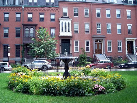
The South End is a neighborhood of Boston, Massachusetts. It is bordered by Back Bay, Chinatown, and Roxbury. It is distinguished from other neighborhoods by its Victorian style houses and the many parks in and around the area. The South End is the largest intact Victorian row house district in the country, as it is made up of over 300 acres. Eleven residential parks are contained within the South End. In 1973, the South End was listed in the National Register of Historic Places. Much of the South End was originally marshlands in Boston's South Bay. After being filled in, construction of the neighborhood began in 1849. It is home to many diverse groups, including immigrants, young families, and professionals, and it is very popular with the gay and lesbian community of Boston. Since the 1880s the South End has been characterized by its diversity, with substantial Irish, Jewish, African-American, Puerto Rican (in the San Juan Street area), Chinese, and Greek populations. In 2010, the population was 55.2% white, 13.3% Hispanic, 12.5% Black or African American, 16.2% Asian, and 2.7% other; 55.2% of its residents had a bachelor's degree or higher; the median household income was $57,699; the median age was 36; 65.6% were primarily English speakers; and 12.9% were primarily Spanish speakers.The South End has five primary and secondary schools that offer education from kindergarten to grade 12.
Excerpt from the Wikipedia article South End, Boston (License: CC BY-SA 3.0, Authors, Images).South End, Boston
Tremont Street, Boston South End
Geographical coordinates (GPS) Address Nearby Places Show on map
Geographical coordinates (GPS)
| Latitude | Longitude |
|---|---|
| N 42.34385 ° | E -71.071863888889 ° |
Address
Harold B. Olliver Square
Tremont Street
02118 Boston, South End
Massachusetts, United States
Open on Google Maps


