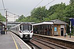
Crews Hill
AC with 0 elementsAreas of LondonCrews HillDistricts of the London Borough of EnfieldPlaces formerly in Middlesex ... and 3 more
Places in Enfield, LondonUse British English from August 2015Villages in London

Crews Hill is an elevated and green-buffered former hamlet grown into a small village-size community on the northern outskirts of London centred 12.3 miles (20 km) north of Charing Cross. It forms part of the London Borough of Enfield and economically has many garden centres and plant nurseries. It is the northernmost settlement in the entire county of Greater London bordering the M25 and the Welwyn Hatfield district of Hertfordshire to the north; it was historically part of the county of Middlesex.
Excerpt from the Wikipedia article Crews Hill (License: CC BY-SA 3.0, Authors, Images).Crews Hill
Theobalds Park Road, London
Geographical coordinates (GPS) Address Nearby Places Show on map
Geographical coordinates (GPS)
| Latitude | Longitude |
|---|---|
| N 51.678 ° | E -0.097 ° |
Address
Hail & Ride Wildwood
Theobalds Park Road
EN2 9BS London (London Borough of Enfield)
England, United Kingdom
Open on Google Maps


