Tung Lung Chau
Islands of Hong KongSai Kung DistrictTung Lung ChauUninhabited islands of Hong Kong

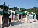
Tung Lung Chau, previously known as Nam Tong Island or Nam Fat Tong is an island located off the tip of the Clear Water Bay Peninsula in the New Territories of Hong Kong. It is also referred to by Hong Kong people as Tung Lung To or Tung Lung Island (東龍島). The island is largely uninhabited. Administratively, it belongs to Sai Kung District.
Excerpt from the Wikipedia article Tung Lung Chau (License: CC BY-SA 3.0, Authors, Images).Tung Lung Chau
High Junk Peak Country Trail, Sai Kung District
Geographical coordinates (GPS) Address Nearby Places Show on map
 Continue reading on Wikipedia
 Geographical coordinates (GPS)
| Latitude | Longitude |
|---|---|
| N 22.249166666667 ° | E 114.28972222222 ° |
Address
High Junk Peak Country Trail
Sai Kung District
Hong Kong, China
Open on Google Maps