Saint-Cyr-l'École
Communes of YvelinesPages including recorded pronunciationsPages with French IPAPages with disabled graphsYvelines geography stubs

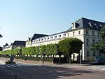
Saint-Cyr-l'École (French pronunciation: [sɛ̃ siʁ lekɔl] ) is a commune in the western suburbs of Paris, France. It is located 21.4 km (13.3 mi) from the centre of Paris. It used to host the training school for officers of the French army, the École spéciale militaire de Saint-Cyr (ESM), which was relocated to Coëtquidan in 1945. The old buildings of the ESM are now used by the lycée militaire de Saint-Cyr (military high school of Saint-Cyr). Inhabitants are called Saint-Cyriens (uppercase, with students or graduates from the school called saint-cyriens with lowercase).
Excerpt from the Wikipedia article Saint-Cyr-l'École (License: CC BY-SA 3.0, Authors, Images).Saint-Cyr-l'École
Rue Gabriel Péri, Versailles
Geographical coordinates (GPS) Address Nearby Places Show on map
Geographical coordinates (GPS)
| Latitude | Longitude |
|---|---|
| N 48.8008 ° | E 2.0633 ° |
Address
C.F.C
Rue Gabriel Péri 10
78210 Versailles
Ile-de-France, France
Open on Google Maps


