place

Bearsden

Archaeological sites in East DunbartonshireBearsdenBurghsForts of the Antonine WallGreater Glasgow
New KilpatrickPages including recorded pronunciationsRoman auxiliary forts in ScotlandTowns in East DunbartonshireUse British English from March 2013
Coat of Arms of the Burgh of Bearsden, 1959 1975

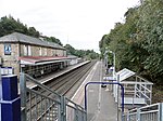
Bearsden ( (listen)) is a town in East Dunbartonshire, Scotland, on the northwestern fringe of Greater Glasgow. Approximately 6 miles (10 km) from Glasgow City Centre, the town is effectively a suburb, and its housing development coincided with the 1863 introduction of a railway line. The town was named after Bearsden railway station, which was named after a nearby cottage. Bearsden was ranked the seventh-wealthiest area in Britain in a 2005 survey, and has the least social housing of any town in Scotland. The Roman Antonine Wall runs through the town, and the remains of a military bath house can be seen near the town centre. In 1649, the first New Kilpatrick parish church was built, which became the centre of administration for the area. The town's official Gaelic name Cille Phàdraig Ùr (meaning "new church of Patrick") reflects the name of the parish. By the early 20th century, a town had grown, with large townhouses, primarily occupied by wealthy commuter business workers. Further development of more affordable housing has increased the population of the town to approximately 28,000. Formerly a burgh, the town now has local government being the responsibility of East Dunbartonshire Council, but until 2011, the council had some departmental offices at Boclair House in Bearsden.

Excerpt from the Wikipedia article Bearsden (License: CC BY-SA 3.0, Authors, Images).

Geographical coordinates (GPS)

Latitude Longitude
N 55.9195 ° E -4.3337 °
placeShow on map

Address

Roman Road

Roman Road
G61 2SS , Hillfoot
Scotland, United Kingdom
mapOpen on Google Maps

Coat of Arms of the Burgh of Bearsden, 1959 1975
Share experience

Nearby Places

New Kilpatrick
New Kilpatrick

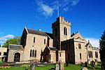
New Kilpatrick, (also known as East Kilpatrick or Easter Kilpatrick) is an ecclesiastical Parish and former Civil Parish in Dunbartonshire. It was formed in 1649 from the eastern half of the parish of Kilpatrick (also known as Kirkpatrick), the western half forming Old Kilpatrick. New Kilpatrick is also a disused name for the town of Bearsden. Originally spanning a large area from Strathblane in the North to Baldernock and Summerston (on the River Kelvin) in the East, down to Anniesland in the South and Yoker and Duntocher in the West, a quarter of the parish was once in the county of Stirlingshire. The geography of the area has supported mining, iron-working and quarrying in the past, but these are no longer economically viable, and much of the area functions as suburbs of Glasgow. Local government of the area was once the responsibility of the kirk, but is now administered by East Dunbartonshire, Glasgow and Stirlingshire councils. The name New Kilpatrick was dropped from general civil use in 1958 when Bearsden Burgh was formed. The previous extent of New Kilpatrick can be seen quite clearly on old maps, but current maps no longer show the former parish. As the population of the area grew, the ecclesiastical parish reduced in area as smaller parishes were separated off and the parish now covers only a fraction of the town of Bearsden. The parish church was built in 1649 from local stone, and was replaced in 1807 with a larger building.